
The Canadian Forest Fire Danger Rating System (CFFDRS), a national system to evaluate the potential of wildland fires was last updated in the early 1990s. Since then, there have been many advancements in technology including automated weather station networks, computing power and remote sensing products. Research has also continued and new models to assess fire behaviour have been developed.
While the basic structure of the CFFDRS remains the same, the goal of the updated system (CFFDRS2025) is to:
- increase flexibility to take advantage of new data sources
- incorporate new models
- integrate changes more easily
- continue to be responsive to wildland fire management needs
The CFDRS2025 consists of four, linked sub-systems. The updates to each sub-system will be released in stages, starting with the next generation Fire Weather Index System (FWI2025).
CFFDRS2025 sub-systems
Each sub-system of the CFFDRS2025 focuses on a different scale and aspect of fire management and behaviour.
- Fire Weather Index System is a landscape level system that uses hourly weather and standard fuel types (pine and grasslands) to track basic fire behaviour day-to-day.
- Fire Behaviour Prediction System provides quantitative estimates of fire behaviour (i.e. spread rate, flame length). Users familiar with this module will see increased flexibility with this system.
- Fuel Moisture System provides information on how fuel moisture changes in different forests. The Fuel Moisture System will inform fire behaviour estimates in an increasing variety of forests modified by natural processes like forest pest infestation or by humans conducting forest thinning and other wildland fire risk reduction activities.
- Fire Occurrence Prediction System provides regional occurrence products to inform users of the likelihood of new ignitions from human and lightning causes within short forecast periods (1 to 3 days).
Next-Generation Fire Weather Index System
Updates to the Fire Weather Index System (FWI2025) aim to modernize the foundation of the calculation methodology. Wildland fire management and academic users can utilize higher resolution data sources (e.g., hourly weather) within a consistent and scientifically sound framework. Fire danger calculations will better capture the implications of variations in weather patterns.
FWI2025 maintains the relative simplicity of the original system while better accounting for the critical elements that influence fire danger. The calculation of codes and indexes change based on hourly weather observations that better reflect changes throughout the day. FWI2025 continues to track conditions in a mature pine forest, but will also introduce new optional codes and indexes for grassland fuels. The grasslands codes and indexes follow the same structure as those for a pine forest stand. Work on indices for peatland fuels is ongoing.
Text version
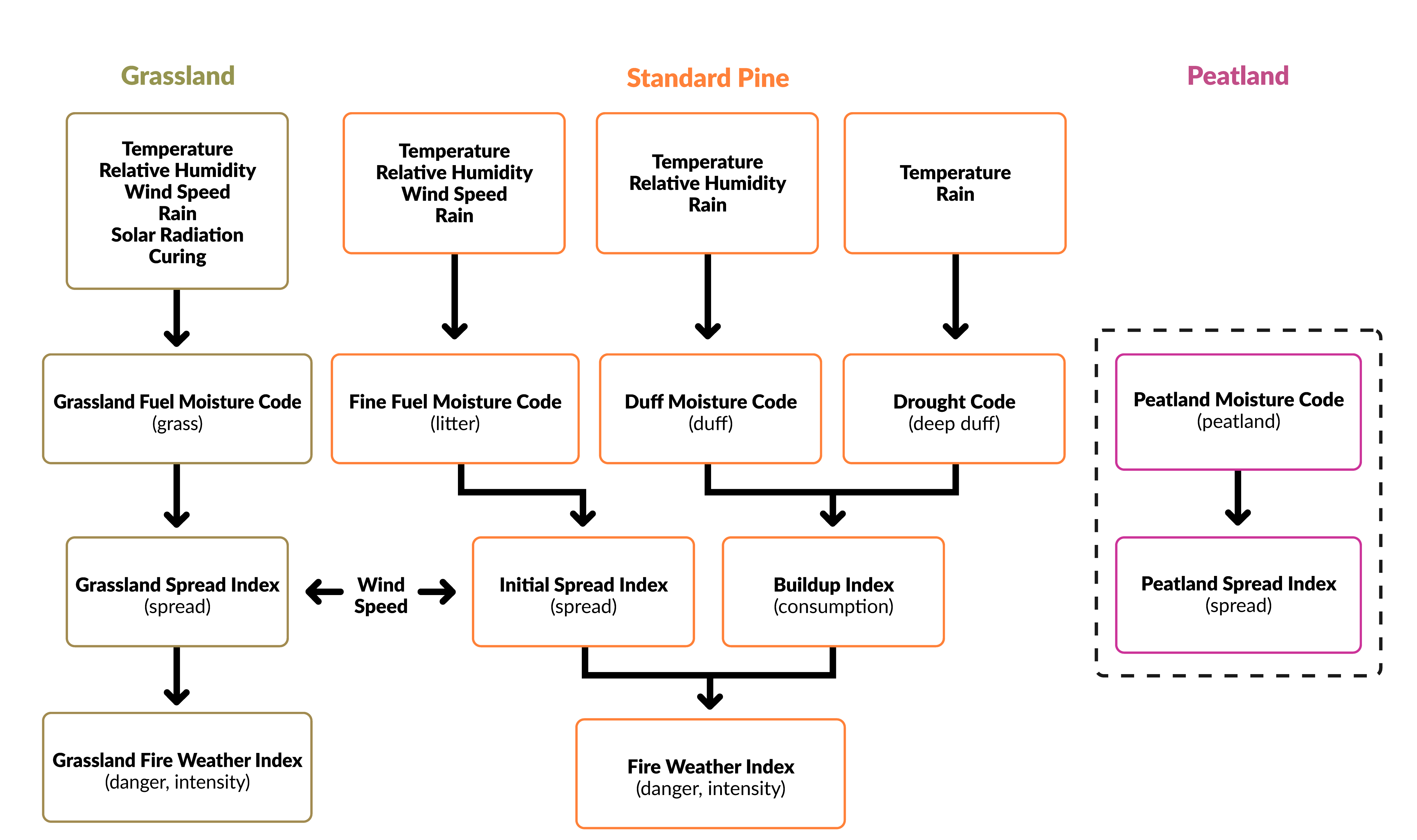
Flow chart showing fuel moisture codes and fire behaviour indices for grassland, standard pine, and peatland fuel types.
Inputs of the Grassland Fuel Moisture Code are:
- temperature
- relative humidity
- wind speed
- rain
- solar radiation
- curing
The Grassland Fire Weather Index (danger, intensity) results from the combination of wind speed and Grassland Spread Index (spread), which is an output of the Grassland Fuel Moisture Code.
The Fire Weather Index (danger, intensity) for standard pine fuel type results from the combination of wind speed, Initial Spread Index (spread) and Buildup Index (consumption), which are outputs of the Fine Fuel Moisture Code (litter), the Duff Moisture Code (duff) and the Drought Code (deep duff).
Inputs of the Fine Fuel Moisture Code (litter) are:
- temperature
- relative humidity
- wind speed
- rain
Inputs of the Duff Moisture Code (duff) are:
- temperature
- relative humidity
- rain
Inputs of the Drought Code (deep duff) are:
- temperature
- rain
The Peatland Fuel Moisture Code (peatland) and the Peatland Spread Index (spread) are under development.
Find out more
- Wildland fire research
- Wildland fire monitoring and reporting tools
- Canadian Wildland Fire Information System
- Fire behaviour
- Wildland fires