
Issue 5, September 2025
On this page:
- When, where, and how often?
- A polar-orbiting mission, making connections in the Arctic circle
- New publications
- Contribute to the research
- Contact us
- Find out more
When, where, and how often?
The WildFireSat mission overpass time and coverage
Overview
The WildFireSat constellation will cover all of Canada, twice daily
To plan daily operations or respond to wildland fires, fire managers need to know when and how often their areas of concern will be observed. This information helps them plan where and when to fly fire detection patrols, reconnaissance flights, high-level infrared aircraft, or other means of collecting fire information. When the fire situation is severe, there are not enough aircraft to fly over all the active fires across the vast extent of Canada’s forests.
Satellites can help alleviate the demand for aircraft, especially in the more remote locations that are hard (if not impossible) to fly over. A geostationary satellite orbits Earth at the equator and matches Earth's rotation, appearing fixed over a single spot, whereas a polar-orbiting satellite travels over the poles, allowing it to scan the entire Earth's surface as the planet rotates beneath it. Satellites that provide persistent coverage tend to be in a geostationary orbit. However, the poor view of northern latitudes from their equatorial vantage point makes their data too coarse to meet the operational needs of Canadian fire managers. Polar-orbiting satellites are more suited to monitor the day-to-day fire situations in Canada due to their higher spatial resolution, but they only overpass at certain times of the day.
Existing polar-orbiting satellite systems widely used for wildland fire monitoring make observations in the late morning (satellite [instrument]: Terra [Moderate Resolution Imaging Spectroradiometer {MODIS}], Sentinel-3 [Sea and Land Surface Temperature Radiometer {SLSTR}]) or early afternoon (satellite [instrument]: Suomi-NPP, NOAA-20, NOAA-21 [Visible Infrared Imaging Radiometer Suite {VIIRS}], Aqua [MODIS]) and provide additional observations overnight. WildFireSat is intended to fill the observational gap in the late afternoon, which is typically the driest part of the day and when wildland fires are at their most active in Canada (peak burn). As such, the overpass times of the WildFireSat constellation (7 microsatellites) are planned to be around 16:30 to 18:00 local solar time, with a sympathetic pass at around 04:30 to 06:00 (Figure 1). For more details on the satellites see the WildFireSat data sheet.
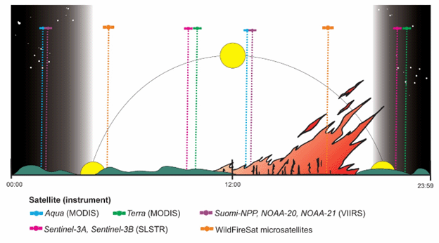
Text version
Infographic showing a horizon and a 24-hour timeline.
A wildland fire is shown getting more active from approximately 12:00 to after 18:00 at its peak. The sun is shown rising before 06:00, highest at 12:00 and setting around 21:00. Satellites and approximate overpass times are Aqua (MODIS) at 13:00 and 01:00; Terra (MODIS), 10:30 and 22:30; Suomi-NPP, NOAA-20, and NOAA-21 (all VIIRS), 13:30 and 01:30; Sentinel-3A and Sentinel-3B (all SLSTR), 10:00 and 22:00; and WildFireSat microsatellites, 18:00 and 06:00.
All times are in local solar time.
Note: MODIS, Moderate Resolution Imaging Spectroradiometer; SLSTR, Sea and Land Surface Temperature Radiometer; VIIRS, Visible Infrared Imaging Radiometer Suite.
Source: Adapted from Johnston et al 2020.
Two observations on any given day and location from the WildFireSat satellites is the daily minimum; there could be more overpasses in a day because the orbits of these 7 satellites converge with increasing latitude. The WildFireSat constellation will provide 3 or 4 observations for locations above 60° north on most days (around 18:00, 2 observations; around 06:00, 2 observations). However, locations south of 60° north will most often receive 2 observations daily, but 4 observations daily may happen occasionally. This coverage is illustrated in Figure 2.
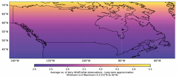
Text version
The map shows geographic coordinates from 72° north (top) to 40° north (bottom) and from 140° west (left) to 50° west (right). The colour gradient ranges from the minimum average of 2.0 observations (purple) to maximum of 5.4 observations (yellow). The number of observations follows a north-south gradient. The most southern areas of Canada (Southern Ontario) are purple (average daily observations, 2). The most northern area, the Canadian Arctic (up to 72° north), is yellow (average daily observations, >5).
Note: This map was modelled by the Canadian Space Agency.
At the 2025 G7 Leaders' Summit, Prime Minister Mark Carney announced that the scope of the WildFireSat mission will be substantially expanded. The WildFireSat mission is expected to collect data and produce fire products for all the vegetated areas of the Earth (unvegetated areas like oceans, deserts, and ice caps will be excluded). This data will be made freely available to support global fire management.
Based on early modelling, for global coverage, the estimated long-term average number of daily observations at the equator is approximately 1.5, equivalent to 3 observations every 2 days (Figure 3 ). Coverage in Northern Europe and Asia is comparable with that in Northern Canada, with a long-term average of 4 daily observations.
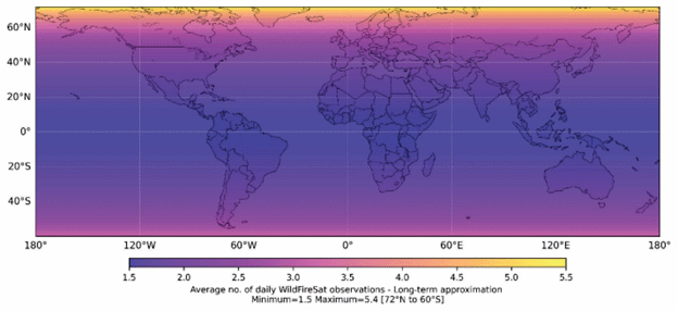
Text version
The map shows geographic coordinates from 72° north (top) to 60° south (bottom) and from 180° west (left) to 180° east (right). The colour gradient ranges from the minimum average of 1.5 observations (purple) to maximum of 5.4 observations (yellow). Coverage varies exclusively as a function of latitude and is symmetrical about the equator. The equator is purple (average daily observations, 1.5). The maximum northern coverage occurs at 72° north (average daily observations, >5), corresponding with the lower Canadian Arctic islands and Northern Scandinavia/Russia. The southern extent of the map is cropped to a lower latitude than the north (60° south vs 72° north), due to the absence of vegetated landmass beyond the tip of South America. The maximum southern coverage occurs at 60° south (average daily observations, 3).
Notes: Data collection will only take place over vegetated areas. This map was modelled by the Canadian Space Agency.
A polar-orbiting mission, making connections in the Arctic circle
Connecting with the fire management community is core to the WildFireSat mission
Overview
The WildFireSat team participated in the annual Arctic Development Expo in Inuvik, Northwest Territories
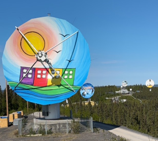
A highlight of the Northwest Territories visit was a tour of the Inuvik Satellite Station Facility and the satellite antennas, like those that will receive data from the WildFireSat microsatellite constellation.
In June 2025, the WildFireSat team conducted outreach engagements in Inuvik, Northwest Territories. They participated to increase awareness about the mission, especially in northern regions where WildFireSat observations will be most frequent in Canada. This included participation in the annual meeting of the Inuvik Satellite Station Facility at the Aurora Research Institute and attendance at the Arctic Development Expo.
At the expo, the team participated in the “Communications and Satellites for a Secure Arctic” panel discussion and represented WildFireSat at a booth alongside the Canada Centre for Mapping and Earth Observation. Importantly, the WildFireSat team visited the Government of the Northwest Territories Shell Lake wildland fire base to meet directly with local fire managers. The visit offered valuable insight into the daily challenges the fire managers face and their perspectives on how satellite-based fire intelligence could support their efforts on the ground.
Visiting Inuvik offered a chance to hear directly from local rights holders, stakeholders, and fire managers about northern perspectives on managing wildland fire. It also created an opportunity to share information about the WildFireSat mission and its potential benefits for the region. These types of outreach activities are part of the team’s commitment to meeting the needs of Canadian fire managers.
Learn more about the pathway for implementation and uptake in provincial and territorial fire management agencies .
New publications
Documenting the science and outreach of the mission
The WildFireSat Science and Applications Plan
This document outlines the scientific data products that will be produced by Natural Resources Canada’s (NRCan’s) Canadian Forest Service (CFS) as part of the WildFireSat mission and what they may look like.
Canadian Space Agency WildFireSat Mission Requirements Document
The WildFireSat Mission Requirements Document, authored jointly by CSA and NRCan, provides a comprehensive overview of the technical specifications that the mission must meet to successfully fulfill the needs of the user community.
Charting constellations: The 2024 CIFFC and WildFireSat fire agency meeting
In November 2024, a workshop was held in St John’s, Newfoundland and Labrador, which was supported by their fire management branch and coordinated by the Canadian Interagency Forest Fire Centre (CIFFC). CIFFC’s participation was part of an ongoing collaboration with CFS and the WildFireSat mission.
WildFireSat: The World’s first government-owned satellite mission specifically designed to monitor all active wildland fires across Canada daily
A high-level overview pamphlet of the WildFireSat Mission, the World’s first government-owned satellite mission specifically designed to monitor all active wildland fires across Canada daily.
Contribute to the research
Help shape the future of fire monitoring in Canada!
Are you involved in fire monitoring in Canada through research, operations, Indigenous stewardship, public service, or industry? We want to hear from you.
CFS is conducting a national survey and follow-up interviews to better understand the collaborations, barriers, and lived experiences of fire-monitoring professionals across Canada.
Your voice will contribute to recommendations aimed at strengthening collaboration and support for fire monitoring in Canada. The survey is anonymous and takes about 20 to 30 minutes to complete.
Survey link
Fire monitoring survey (~20–30 min)
Volunteer for an interview
Fire monitoring interview (optional and fully confidential)
A note about third-party information
Information provided by external sources is subject to change at any time. The Government of Canada is not responsible for the accuracy, reliability or timeliness of the information supplied by external sources. If you plan to rely upon this information, you should consult directly with the source of information. Content provided by external sources is not subject to official languages, privacy or accessibility requirements.
Contact us
For more information, send an email to wildfiresat-gardefeu@nrcan-rncan.gc.ca. To subscribe to this e-Bulletin, please include “Subscribe me to the WildFireSat e-bulletin” in the subject line of your email.