
Table of contents
- Message from the Surveyor General
- Surveyor General Branch – Who we are
- Our programs
- Program evaluation
- Special projects
- Strategic priorities and highlights 2023 to 2024
- Acronyms
- Annex 1: Contact us
- Annex 2: Program metrics
- Annex 3: SGB Projects dashboard
- Annex 4: Publications
- Annex 5: Human resources data
Message from the Surveyor General
I am pleased to present the Surveyor General Branch’s (SGB) annual report for the 2023 to 2024 fiscal year, showcasing our achievements, projects, and publications over the last fiscal year. This report is the first one reporting on the new SGB integrated business plan (IBP) developed for the period of 2023 to 2026. This IBP defines our new strategic priorities for the next three years and 18 new projects have been identified and are being implemented to support these new priorities.
Our priorities align with the priorities of the Government of Canada that are designed to grow the economy and stimulate innovation. Our programs fall into Natural Resources Canada’s (NRCan) first core responsibility: Natural Resource Science and Risk Mitigation. Our work influences government policy and priorities, and our programs continue to generate new information and ideas about Canada’s lands and land management tools and practices.
This year’s annual report highlights the achievements made in our three current strategic priorities, namely:
- Indigenous Peoples’ control of their lands and Northern land management
- Spatially enabling Canada to ensure the future well-being of our economy
- Protection of Canada’s oceans
The report will also describe the advancements made on a few of our special projects, namely the modernization of the Canada Lands Surveyors Act, the modernization of the Canada Lands Surveys Act, and the creation of new publications describing the survey process on First Nation lands.
This report will also discuss how the SGB is responding to current and future challenges. Even with the COVID-19 pandemic behind us, the SGB still faces many challenges that are being addressed to ensure we can continue to deliver on our programs and to ensure Canadians continue to have access to secure and reliable land survey systems, clearly defined boundaries, and accurate positioning information. Some of the challenges that surfaced were 1) the major forest fires in the North that affected our regional office in Yellowknife; 2) the new hybrid work model implemented across the department; 3) the changing technologies affecting our daily operations; and 4) the human resources (HR) capacity we continue to face with the departure to retirement of several of our senior professionals.
Thanks to the hard work and dedication of all our employees, we have been able to meet the many challenges and have experienced great success in all our projects.
Happy reading! I invite you to review and provide comments on the report, and I thank you for your continued engagement.
Jean Gagnon
Surveyor General of Canada Lands
Canadian Commissioner, International Boundary Commission
Director General, Surveyor General Branch
Surveyor General Branch – Who we are
Our continued mission is to ensure that Canadians have access to secure and reliable land survey systems, clearly defined boundaries, and accurate positioning information to meet Canada’s economic, social, and environmental needs.
In 2023 to 2024, we had:
- A budget of $26,878,902
- 157 employees, including survey engineers, Canada Lands surveyors, geodetic engineers, research scientists, policy analysts, survey technicians and support staff
- Ten regional offices across Canada and one office in the National Capital Region (see Annex 1. Contact us!).
- A dynamic workforce comprised of full-time and part-time staff, students, and seasonal staff
Our programs
We continue to focus on three key programs that align with several government priorities and commitments. Our work contributes to NRCan’s core responsibilities related to natural resource science and risk mitigation by providing important information about Canada’s lands and supporting vital land management tools and practices.
- The Canada Lands Survey System (CLSS) helps to define, demarcate, and describe property boundaries and the extent of property rights for Canada Lands – the North, First Nations reserve lands, national parks, and offshore. With boundary certainty and a well-maintained property rights system, stakeholders can focus on community well-being and economic growth. A strong land survey system is especially significant to support Indigenous self-governance.
- The Canadian Geodetic Survey (CGS) of the SGB provides foundational positioning infrastructure and a fundamental reference framework that facilitates the accurate measurement of latitude, longitude, elevation, and gravity in Canada. It also monitors the motion of our continental land mass in support of geomatics and geoscience. These measurements are important not only for boundaries, but for anything for which precise geolocation matters, enabling mapping, land surveying, water management, and monitoring of natural hazards and engineering activities in Canada.
- The Canadian Section of the International Boundary Commission (IBC), in co-operation with its United States counterpart, preserves and maintains a clear and visible boundary between Canada and the United States. This work includes maintaining the boundary monuments and open vistas through forested areas as well as regulating construction and work within 3 metres of the 8,891-kilometre boundary. Having a clearly visible Canada-United States boundary is essential to the safety of citizens who carry out activities near the border and to law enforcement agencies for protecting the security of Canadians and preserving our sovereignty.
Program evaluation
Throughout the year, we continuously evaluate the quality of our programs. This is to ensure that we are delivering on our commitments effectively and are providing high quality products and services to our clients. Each program is measured against a series of performance indicators, allowing us to assess the performance of each program on a regular basis (see Annex 2. Program metrics).
In early 2023, the SGB developed its new IBP 2023-26 that covers the next three fiscal years. In this plan, a series of projects and activities were identified as essential to support our vision for the next three years and beyond. Since the implementation of the new IBP, the SGB has been tracking the progress and results of key projects supporting our three strategic priorities, as well as those that help improve our daily operations.
These projects and activities are monitored through a dashboard that is updated every two months and shared with all employees (see Annex 3. The SGB Projects Dashboard). In 2023 to 2024, which is the first year of the new IBP 2023-26, 17 of the 18 projects were initiated and are progressing well. The last project will begin in 2026.
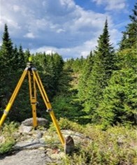
A survey tripod installed in a wooded area on the international boundary in the Highlands section, east of Saint Théophile, Quebec, and Maine
International Boundary Commission
Compared to other SGB programs, the IBC has a different status within the Lands and Minerals Sector (LMS) and NRCan. The IBC has both an American and Canadian commissioner who is responsible for their own budget, equipment, and staff. For Canada, according to the International Boundary Commission Act, the Surveyor General is Canada's commissioner. The Canadian commissioner reports to the Minister of Foreign Affairs on policy matters and is an employee of NRCan for administrative and operational purposes.
For fiscal year (FY) 2023–2024, the Canadian section of the IBC undertook and successfully completed another ambitious field season. The IBC hired three new employees, including an operations manager to assume the duties of leading the operations and staff of the Canadian section. The Canadian section successfully completed nine field projects in various areas of the international boundary from New Brunswick to British Columbia. Every year, a joint report is submitted to both the governments of Canada and the United States, as per Section IV of the Treaty of 1925. Each report details the yearly activities of the IBC and can be found on the IBC website: www.internationalboundarycommission.org.
Special projects
Canada Lands Surveyors Act
In 2016, the Association of Canada Lands Surveyors (ACLS) submitted a request to the Minister of Natural Resources to amend the Canada Lands Surveyors Act. The amendment was to allow for a more transparent and robust complaints and discipline process and to better align with the Canadian Free Trade Agreement (CFTA) respecting labour mobility.
In 2021 to 2022, the SGB began the modernization of the Canada Lands Surveyors Act. The modernized act will reflect the evolving responsibilities of a self-governing profession. The update will also address the 2016 ACLS request to make the complaints and discipline process more transparent and robust while reducing the regulatory burden on government and industry.
On March 31, 2022, the Regulatory Modernization Bill was introduced in the Senate and included proposed changes to the Canada Lands Surveyors Act. The bill’s first reading took place on June 22, 2022, in the House of Commons. Its second reading took place on June 19, 2024, and was assigned to a standing committee.
The SGB is actively monitoring the progress of the Canada Lands Surveyors Act. In collaboration with the ACLS, the SGB has developed instructions to facilitate the modification of the Canada Lands Surveyors Regulations when the modernized Canada Lands Surveyors Act is enacted. Additionally, the ACLS is working on adjusting its by-laws to align with the anticipated changes made to the Canada Lands Surveyors Act and regulations. This coordinated effort ensures that the SGB will have the necessary by-laws ready for implementation in accordance with the provisions of the Canada Lands Surveyors Act. Following royal assent and the modification of the regulations, the SGB will proceed with seeking approval through Orders in Council to bring the Canada Lands Surveyors Act into force.
Modernization of the Canada Lands Surveys Act
The Canada Lands Surveys Act provides a policy framework for regulating land surveying on Canada Lands. Canada Lands include lands in the Yukon, the Northwest Territories, and Nunavut; more than 3,100 First Nations reserve lands; Canada’s national and historic parks; and Canada’s offshore area as defined in Section 24 of the Canada Lands Surveys Act.
Since the Canada Lands Surveys Act came into effect in 1985, it has not been modified to reflect or support the significant advances made by Indigenous Peoples in the aspects of land management and self-governance. Input from Indigenous Peoples, governments, and organizations on the modernization of the Canada Lands Surveys Act is crucial to recognize and support their inherent right to self-determination and to align with the United Nations Declaration on the Rights of Indigenous Peoples Act and other federal Indigenous reconciliation principles. It is also necessary to determine what considerations need to be made when modernizing the Canada Lands Surveys Act (e.g., terminology, concepts, process or provisions within the act).
The SGB has created an engagement plan that outlines the steps and resources required to engage Indigenous stakeholders. In early 2024, the SGB began phase 1 of its engagement process, seeking feedback from Indigenous Peoples, governments, and organizations on their preferred method of engagement.
Publications describing the survey process on First Nation Lands
The SGB has published two guides this year that describe the survey process on First Nation Lands. These publications are intended to provide First Nations with information, tools, and links to additional resources when considering having land survey work conducted on their lands.
One guide addresses the survey process on First Nation Lands managed under the Indian Act, while the other guide addresses the survey process on First Nation Lands managed under a land code.
The format of each guide is intended to help the reader determine the level of information they require on the surveying process. This could be from a high-level overview of the survey project process in a checklist-style format to a more detailed explanation of the process with helpful tools and examples.
While First Nation land managers are the intended audience of these publications, these guides may provide valuable information to land surveyors and other government departments that may not be familiar with each of these two processes.
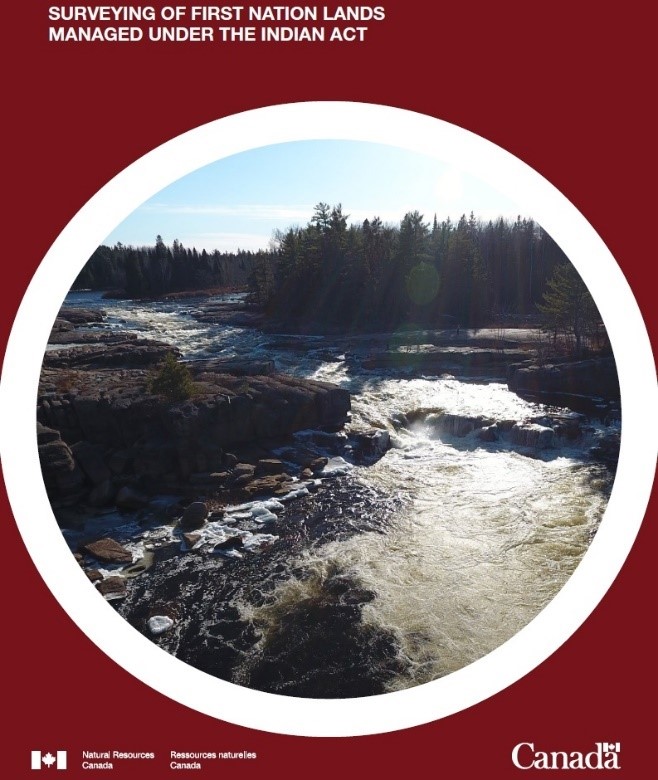
Cover of the Surveying of First Nation Lands Managed Under the Indian Act document
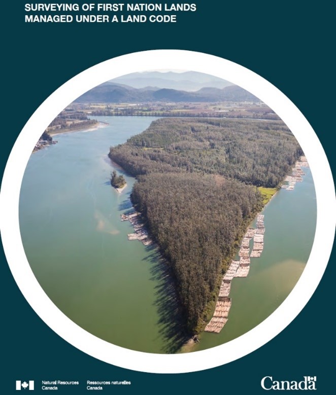
Cover of the Surveying of First Nation Lands Managed Under a Land Code document
Strategic priorities and highlights 2023 to 2024
Priority 1. Indigenous Peoples’ control of their lands and Northern land management
During the last fiscal year, the SGB continued its efforts to support Indigenous self-governance through the First Nation Land Management (FNLM) Survey Capacity Development program (SCDP) and several other activities that took place in our regional offices across the country.
Our efforts continue to include more time for conversations with communities about their history and traditional land management practices to create a stronger relationship through the sharing of knowledge in a forum of mutual respect.
First Nations Land Management Survey Capacity Development Program
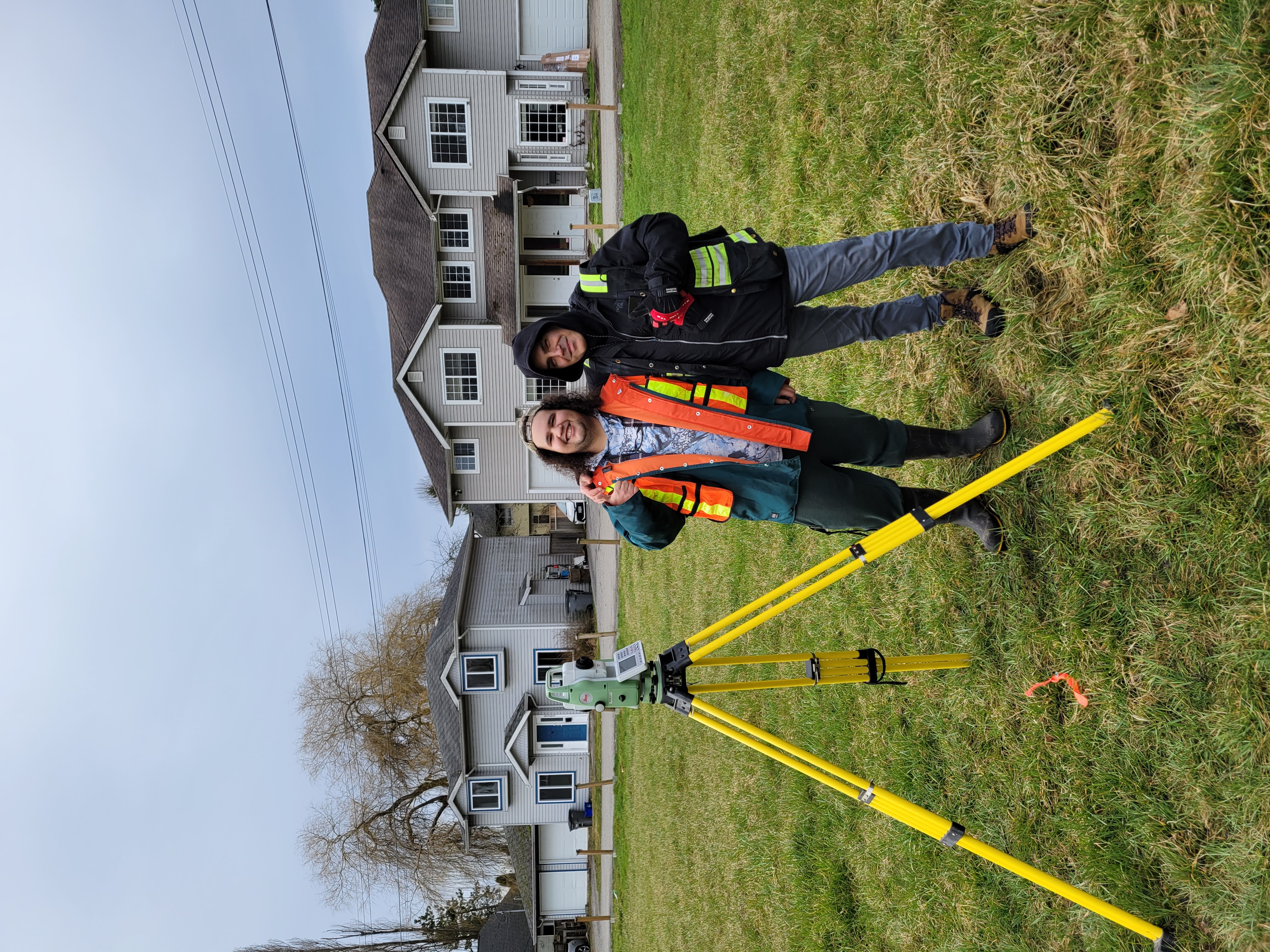
Training and field activities with the Musqueam Indian Band
The SGB Regional Offices have prioritized the survey capacity development initiative with First Nation communities throughout 2023 to 2024. In British Columbia (B.C.), the program was successfully completed with the Musqueam Indian Band, Soowahlie First Nation, and Lytton First Nation. The program currently continues with the Lower Nicola Indian Band. Over a four-week period, our regional office in British Columbia has been delivering in-community training to the Lower Nicola Indian Band with plans to extend the engagement for another three to four weeks.
With the Musqueam Indian Band in particular, the program focused on enhancing land management and boundary maintenance skills through offering practical survey training tailored to the community’s specific needs. Participants acquired advanced skills in maintaining legal boundaries and their impact on land management operations through hands-on training, such as the cemetery extension project, which served as a real-world case study. This initiative enhanced Musqueam’s land surveying project management processes and promoted strong partnerships between local surveyors and the lands team.
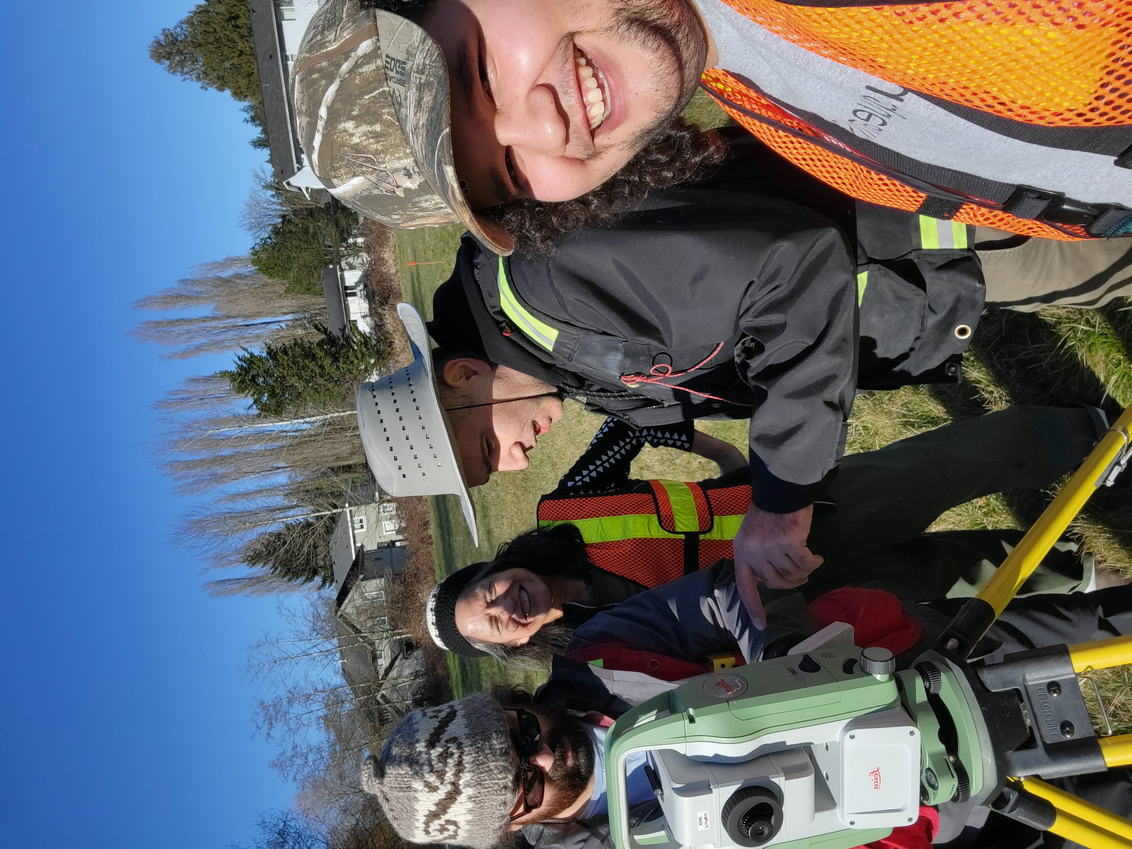
Training and field activities with the Musqueam Indian Band
This national program team also completed four one-day sessions and 18 one-week sessions between Peerless Trout First Nation (Alta.), Muskeg Lake Cree Nation (Sask.), Fishing Lake First Nation (Sask.), Kahkewistahaw First Nation (Sask.), Opaskwayak Cree Nation (Man.), Mississaugi First Nation (Ont.), Sheshegwaning First Nation (Ont.), and Timiskaming First Nation (Que.) communities. This was in addition to attending and contributing to sessions hosted by Indigenous Services Canada (ISC), the Ontario Aboriginal Lands Association (OALA), the Saskatchewan Aboriginal Lands Technicians (SALT), Treaty 4 Celebrations, and the First Nations Education Administrators Association (FNEAA).
In February, an internal SGB working group was formed to review the program and provide a plan to reconfigure and integrate the SCDP concept into the activities of the FNLM core program. A change to the program title, now known as Land and Survey Knowledge Sharing, and a reconfiguration of the program outreach, subject matter, and resources were carried out. This was to better align the program with each First Nation’s needs as they progress through the developmental and operational phases regarding their land code development and implementation under the Framework Agreement on First Nations Land Management (framework agreement). Discussions continue with the First Nation Land Management Resource Centre (FNLMRC) as to the specifics of the program, such as appropriate timeframes to initiate the program with First Nation communities, the subject matter, and program materials.
The main fundamentals of the SCDP will continue under the new program. There will be a clearer focus on fostering significant, long-term relationship building between the SGB and First Nations with in-person sessions promoting mutual learning and collaboration. The SCDP emphasizes the role of the Canada Lands Surveys System in addressing boundary-related complexities. In addition, the SGB staff will gain a deeper understanding of land issues and history from the First Nation’s perspective. It is anticipated that these interactive, mutual learning and collaborative sessions will mark progress in reconciliation efforts with First Nation communities and the FNLM Resource Centre.
Land and Survey Knowledge Sharing Program
The Land and Survey Knowledge Sharing Program allows the SGB staff to engage more meaningfully with community members, particularly First Nation staff involved in land-related activities.
Field activities, including the introduction to conventional surveying, is a key part of the training offered to First Nation communities. The training has been well received so far and offers land staff valuable insights into the land surveying process, deepening their understanding and engagement.
The program sparks interest among First Nation youth in pursuing land surveying as a future career, highlighting the significant benefits of the profession. By entering the surveying workforce, they gain the skills to serve and support their communities in managing land-related activities.
First Nations Land Management: Research and land description reports
Ten new First Nations (with a total of 86 reserves) joined the Framework Agreement developmental process very late in the last fiscal year, with five new First Nations (with a total of six reserves) joined the developmental process this fiscal year. In addition, First Nations are starting to re-engage in the developmental process where they had previously paused their pursuit of a land code. For example, in 2017, research reports and land descriptions were completed for 62 reserves of the Norway House Cree Nation. However, as of this fiscal year, the Norway House Cree Nation has an additional 22 new reserves requiring research reports and land descriptions in addition to confirming and updating the previously prepared descriptions. There is a lot of work for the SGB to complete and keep up with the momentum of First Nations’ in moving towards regaining their inherent right to self-governance.
An adjustment to the process for the preparation and sharing of the research reports as part of FNLM was made last fiscal year. Following the completion of the research report, the SGB now shares the report with both ISC and the First Nation at the same time. This new process appears to have been well received as a more effective and transparent method of communication as it keeps all parties updated on the current situation. The SGB has been available to meet with ISC regional officials and/or the First Nation to present and explain the research found in the report and to listen to and consider any new issues or concerns raised. The SGB will continue to consult with ISC throughout the process. When any significant issues are identified, they will be clearly communicated as soon as possible. This will be done to have the issues addressed, where possible, prior to the completion of the research report.
First Nation Land Governance Registry
Since 2022 and until March 2028, the SGB is fully engaged in a collaborative effort with the Lands Advisory Board (LAB), the FNLMRC, and LandSure, a wholly owned subsidiary of the Land Title and Survey Authority of British Columbia (LTSA) to support the LAB to create a new First Nation Land Governance Registry (FNLGR). The FNLGR is a new entity with the mission of operating this First Nation-owned land registry. Through this partnership, the FNLMRC, LandSure, and the SGB worked together to advance First Nation self-determination and reconciliation by enabling land management to transition under the authority of First Nations.
The SGB is undertaking this project by focusing effort in three phases: 1) information management (IM) and information technology (IT) design and building; 2) policy and governance; and 3) registry migration.
- IM/IT design and building: This year, the IM/IT component of this project was advanced through collaboration with our partners. A development infrastructure between the SGB and LandSure was established, and work began on defining data requirements as well as processes for exchanges and approvals. This phase includes modernizing existing systems to provide mapping services to validate, create, archive, and disseminate graphical representations (polygons) of unsurveyed interests for existing and new short-term and transitory tenures in the registry.
- Policy and governance: The SGB is working on increasing the involvement of First Nations in the land tenure process through its ongoing effort to create a modified and integrated approval process for land surveys on First Nation Land managed under a land code.
- Registry migration: One activity is to support First Nations with the onboarding to the new registry by collaborating with them and preparing reports to present the state of their land regarding survey information and the associated rights. This approach will enable an easier transition to the new registry by identifying areas of concern and will provide an opportunity to work with First Nations to address potential issues before the import process.
Initial research was started with many First Nations, including Lower Nicola Indian Band, Shuswap Band, Nipissing First Nation, and One Arrow First Nation. This year, the SGB engaged with two First Nations, Soowahlie First Nation and Sheshegwaning First Nation, to develop and test a process to complete the registry migration activity. The next steps would be to gain more feedback and approval of the process from First Nations and the FNLMRC.
Boundary maintenance projects for the Tsuut’ina Nation, Piikani Nation, and Cold Lake First Nation
From 2023 to 2024, the Alberta Regional Office completed boundary maintenance projects on portions of Tsuut’ina Nation 145, Piikani 147, and Cold Lake 149. These projects involved investigating the areas for potential encroachments, evaluating and repairing existing survey monuments, and placing custom boundary plaques.
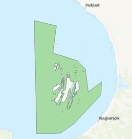
A marine protected area located in Hudson Bay
Nunavut Lands and Resources Devolution Agreement
The Ontario Regional Office has been working alongside the Nunavut Regional Office on projects related to the Nunavut Lands and Resources Devolution Agreement (Nunavut devolution). Online communication between the two offices has led to the creation of maps for marine protected areas (MPA), such as the example shown in Hudson Bay. These biodiversity-rich areas are vital to local ecosystems, and it is important that they are recognized and documented as the devolution agreement comes into place. It has also been great to have the SGB regional offices located so far away from each other, yet working so closely together.
Activities in the North (Yukon, Northwest Territories and Nunavut)
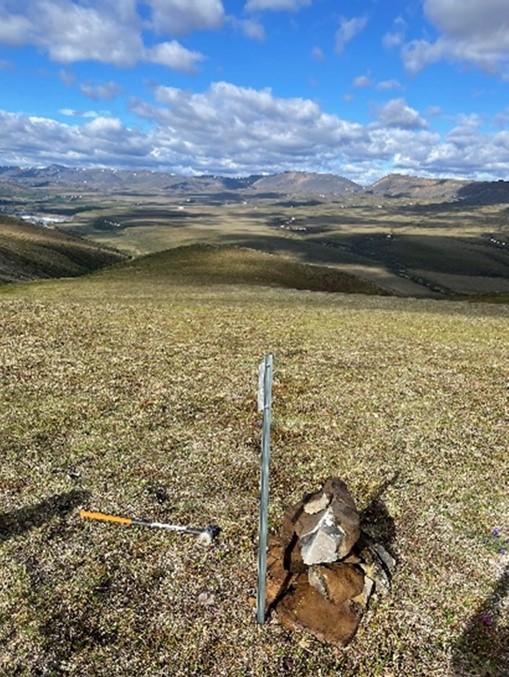
Fieldwork supporting the Gwich’in land survey program
Through the Canada Lands Survey program, the SGB provides the system of land surveys for the three territories. This system is the foundation and an essential component of property rights in the North and is mandated through both federal and territorial legislation.
Extensive work continued with Comprehensive Land Claims Agreements (CLCA) for implementation as well as for supporting technical groups working on future agreements. This year was the third year of the Gwich’in CLCA survey program. Milestones include successful completion of the imagery from which 20 imagery plans were submitted for registration covering the Gwich’in Settlement Area. This was a significant milestone as wildfires and the associated smoke had affected the results from the previous two field seasons. The surveying of boundaries for parcels continued with eight Mylar plans submitted for registration covering 11 parcels. Three partial surveys were also started. Testing, research, and analysis for the use of targets with tasked, georeferenced satellite imagery continued to be used to support continuing and future boundary surveys. Results help to define the use and limitations of this improving technology for parcels in remote locations. Registration of previously submitted plans at the Government of Northwest Territories’ Land Titles Office continued with five documents being recorded.
Work on the CLCAs with agreements in principle, or the agreement that will form the basis of the treaty, continued. This includes the preparation of administrative plans to support the agreements for the Athabasca Denesųłiné and Ghotelnene K’odtįneh Dene.
This past year, there was noteworthy collaboration among the SGB regional offices. This includes the sharing of human resources among northern offices as well as among northern and southern offices. Examples of mutual support include joining field teams from other regional offices, providing custom mapping products for large projects, and collaborating on research and complex survey problems.
This year, the SGB saw an above average effort for the field season to support work for our federal land administration stakeholders. Specifically for the Nunavut devolution, there are only a couple field seasons remaining for federal departments to survey and describe their land holdings. The Nunavut regional office (NRO) had a busy year with additional fieldwork and support for other government departments as they arrange land surveys and the processing of the resulting survey documents.
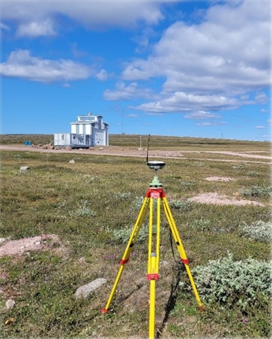
Fieldwork in Baker Lake, Nunavut, performing boundary surveys to describe federal holdings in support of Nunavut devolution
Other efforts specifically for the NRO include working on boundary descriptions for protected areas in the marine environment. These projects are in various stages of development and are scheduled to continue into the coming years. The NRO continued to foster their relationship with the Government of Nunavut’s Department of Community and Government Services. This department is responsible for the coordination, planning, and approval of land survey-related documents. We were invited to their Annual General Meeting in November. In addition to making a presentation on the Canada Lands Survey System, we were included as full participants. This provided an opportunity for all attendees to build a stronger working relationship.
This year, the Yukon Regional Office (YRO) put considerable effort into the digitization of their paper documents. The indexing and access work continues; however, this effort has immediate improvements for document access as well as freeing up physical space in the office. With the return to the office after the COVID-19 pandemic, the YRO made room for other NRCan employees to work in their facilities. This year also saw active effort working with the Crown-Indigenous Relations and Northern Affairs Canada (CIRNAC) and Yukon First Nations that have not yet concluded final or self-government agreements. This work will continue into future years as these First Nation governments and the Government of Canada work out land administration governance and boundary definitions.
Priority 2. Spatially enabling Canada to ensure the future well-being of our economy
The CGS continued to provide the fundamental reference frame and standards for the measurement of latitude, longitude, elevation, and gravity anywhere in Canada and to monitor motions of our continental land mass in support of geomatics and geoscience.
The Canadian Spatial Reference System (CSRS), which defines the standards for positioning in Canada, is undergoing a major update in 2025 to 2026 to modernize and ensure compatibility of geodetic reference systems across North America. This will be done in a joint effort with the United States and Mexico. Preparation for this transition, as well as a major infrastructure expansion and upgrade under the Space-based Earth Observation (SBEO) project, have been the focus of the CGS’s efforts in the past year.
The number of clients seeking essential positioning information through the CSRS-Precise Point Positioning (PPP) service and geodetic tools continues to increase. In 2022 to 2023, 30% more files were processed.
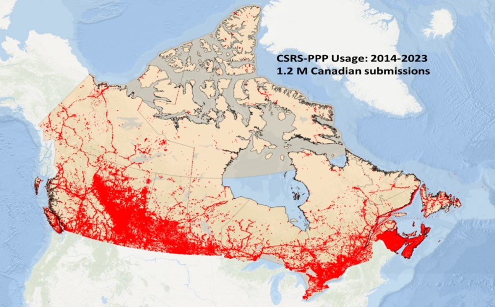
CSRS-PPP usage between 2014 and 2023 in Canada
This service has important applications across a wide range of fields, including professional surveying and engineering, construction, glaciology, geodynamics, and marine science. During FY 2023 to 2024, the CGS had over 12,000 active clients around the world, and almost 1.7 million files were processed.
The CGS continues to actively support geomatics and the geosciences with partners at NRCan, other departments, and academia. For example, the CGS scientists calculate estimates of Total Electron Content (TEC) and scintillation of the ionosphere from national and international Global Navigation Satellite System (GNSS) ground station networks. These are submitted to the International Civil Aviation Organization’s (ICAO) Space Weather Warning Service in addition to other contributions coordinated through the Canadian Hazards Information Service (CHIS). As well, the CGS’s gravity program contributions to the Geological Survey of Canada’s Groundwater Geoscience program and the Canada1Water project were highlighted in the 2023 Canada Water Act annual report to Parliament. The CGS also collaborates with the University of Victoria’s Ocean Networks Canada (ONC) on the application of its real-time GNSS augmentation and PPP services to enhance the assessment of earthquake magnitudes in real-time. This is a novel integration of GNSS and seismic data supporting ONC’s recently launched Earthquake Early Warning capabilities in British Columbia.
Crucial importance of geodetic infrastructure for the economy
The global supply chain for geodesy includes a global network of observatories, data centres, analysis centres, and experts for the measurement of the Earth parameters such as rotation, inclination, centre of mass, and terrestrial and celestial/inertial reference frames. This infrastructure needs to be distributed around the world to achieve the accuracy and reliability required to support the global economy. National economies are increasingly reliant on satellite services, which require information from the Global Geodesy Supply chain (GGSC) to navigate in space. The United Nations Global Geodetic Centre of Excellence is proposing a joint development plan that includes:
- Adequate resources for the GGSC: Operational activities aren’t currently done under formal commitments.
- Governance and awareness: Positioning needs global data (every day). Countries are being asked to strengthen national awareness and governance in geodesy, to recognize this supply chain as national critical infrastructure, and to engage in bilateral or multilateral agreements – such as the World Meteorological Organization or the International Hydrographic Organization.
- Increase capacity: Canada requires a plan to mitigate the “Geodesy Crisis” to recover the national knowledge base in geodesy lost to retirements.
- Although the CGS at LMS computes Canada’s reference frame and geopotential model based on the best information available using GNSS and gravity stations, that is still not sufficient to compute the global reference frame to which all countries and satellites are aligned.
Space-based Earth Observation project
In October 2021, the CGS received funding over five years to expand Canada’s GNSS infrastructure. This would include adding at least 22 GNSS stations to increase the accuracy and availability of real-time positioning, navigation, and timing (PNT) information across Canada. During 2023 to 2024, six new stations were installed in Powell River, B.C., Sault Ste. Marie, Ont., Cambridge Bay, NU, University of Athabasca, Athabasca, Alta., Kakabeka Falls, Ont., and Writing on Stone, Alta. Three of the GNSS regional stations were upgraded to real-time. These were the La Grande 4, Que., Rankin Inlet, Nunavut, and Hearst, Ont., stations.
Also, logistics have been arranged to install nine more GNSS stations during the summer of 2024. These logistics rely on collaborative agreements with the private sector (e.g. Ontario Power Generation), other government departments (e.g. Parks Canada and the Department of Fisheries and Oceans), and universities (University of Athabasca). With these additions, the CGS will contribute to the definition of the International Terrestrial Reference Frame.
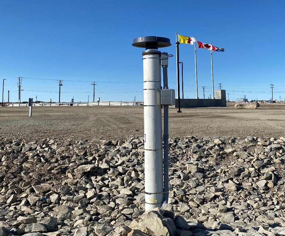
New GNSS station (IQLK) at the Canadian High Arctic Research Station (CHARS) in Cambridge Bay, Nunavut. The traditional Inuinnaqtun name for the area is Iqaluktuuttiaq, which means "good fishing place." The traditional name was used to name this station in recognition of the First Nation’s sovereignty over this area.
Reference system modernizations
Modernization of the CSRS will address increasing accuracy and interoperability requirements across most economic and geoscience sectors, including surveying and construction, mining and forestry, and climate forecasting and adaptation. The CGS will adopt a new North American Terrestrial Reference Frame (NATRF2022) and update the Canadian Geodetic Vertical Datum of 2013 (CGVD2013) with a common North American geoid model. This will be done in parallel with adoption of the new systems by the United States National Geodetic Survey (NGS) in early 2026. An update of the International Great Lakes Datum (IGLD) is planned for 2027.
The past year saw significant collaborative achievements towards defining the new common systems. This includes testing North American plate rotation parameters, updating control network coordinate functions, developing a new North American geoid model, and assessing precision water levels around the Great Lakes. Modernization continued through regular NGS-CGS meetings, updating of the CGS-NGS collaboration agreement, and stakeholder outreach and consultation in partnership with the provincial collaborators across Canada.
With most provinces committed to the adoption of the new frames by 2030, this year saw a shift in outreach focus from cadastral and surveying users towards the geospatial community. This was done to support planning for widespread migration of geospatial data layers held by industry and all public sectors. This also includes the Territories, which is where the SGB provides geodetic control and will have an important role to play in the adoption of and migration to the new standards.
The last planned version update for the existing geometric frame (NAD83[CSRS] version 8) was developed to conform to new international reference frame standards and will be used as a beta model for NATRF2022.
Together, these modernization efforts will ensure Canadians have access to unified and state-of-the-art geo-referencing systems that are aligned with international standards and compatible across North America.
Positioning, navigation, and timing
The CGS continued to engage and collaborate with scientific and geoscience colleagues within Canada on advancing geodetic research and supporting federal coordination efforts related to PNT in Canada. The CGS chairs the Canadian Geodetic Science and Applications Committee (CGSAC) to share information with academic colleagues and advance geodetic research in Canada. The CGS supported collaboration with colleagues within NRCan and with other agencies, such as Fisheries and Oceans Canada, Environment and Climate Change Canada, Transport Canada, and Innovation Science and Economic Development Canada. This collaboration includes raising awareness of PNT issues in Canada, such as the geodesy crisis and the PNT requirements for the transportation sector. The CGS also worked with Oceans Network Canada to integrate real-time GNSS position information with seismic data for future tsunami early warning systems.
Publications
Throughout the year, the CGS was involved in several national and international research projects. The findings of their research can be found in the various publications and presentations published throughout the year (see Annex 4. Publications).
Priority 3. Protection of Canada’s oceans
This year was focused on building the relationships developed from the previous Marine Spatial Governance in Canada workshop series. Two working groups were formed that included representatives from the principal rights, restrictions, and responsibilities departments. The groups had governance and technical objectives, and each contributed towards developing the next steps to improving the governance structure for Canada’s marine environment.
From the working groups, the effort was to focus on standardizing the boundary documents to support Canada’s MPAs and offshore renewables. This included supporting active projects while working to improve the process. Considerable effort was invested in understanding the unique requirements for each of the departments that were active in the marine environment and working out products and processes to match requirements.
Three SGB regional offices and the marine boundary service were actively engaged in a variety of projects that encompassed each of Canada’s three oceans. The projects are at various stages of development and all of them will continue into the next year. This further enforces the complex environment in the marine space as each project requires a unique investigation and solution. The improvements developed in the past year are only a small reflection of what is still required to have an integrated land management regime in the offshore.
Responding to current and future challenges
With the COVID-19 pandemic finally behind us, the SGB was able to move its focus to other current and future challenges, mainly forest fires, the new hybrid work model, changing technologies, and the human resources capacity.
Forest fires
Again, wild forest fires had a major impact on our operations during this fiscal year. The difference this time is that not only did it affect the fieldwork of our survey crews, it also directly impacted our staff in the Northwest Territories Regional Office (NWTRO) as the city of Yellowknife was evacuated in the summer. The staff had a rushed, stressful exit from the city, and each ended up in evacuation centres in different locations. With no known return date, they made the best of their situation and took advantage of their work tools and platforms to stay connected and productive. It was more than three weeks before the evacuation order was lifted and staff could return to their home city. In addition to managing their own personal circumstances during a very stressful time, the NWTRO staff went above and beyond to ensure the security of government assets.
In the field, the month of July 2023 was problematic for the IBC field crews working to maintain the international boundary between the Province of Quebec and the United States. Due to high risk of forest fires in the province, several wooded areas were closed to the public, making it impossible to the field crews to access their work area. The IBC reacted quickly and reassigned the field crews affected by the restrictions to other areas along the international boundary where no forest fire restrictions were in place.
Hybrid workforce
April 1, 2023, saw the introduction of the Government of Canada’s new hybrid work model requiring employees to be physically present at the workplace for two to three days per week or 40% to 60% of their regular work schedule. The SGB implemented this new hybrid work model in all its offices and ensured that the physical work environment respected the new model and met the employees needs.
Changing technologies
As in the previous fiscal year, we continued to face challenges regarding rapidly evolving technology, which requires vigilant monitoring of our systems, processes, and standards.
In 2023 to 2024, the SGB continued to invest in modernizing its IT applications to ensure its long-term viability and to benefit from new technologies such as cloud computing and modern software platforms.
In the second year of its Application Modernization project, the SGB developed cloud versions of its real-time Active Control System application and its cadastral and geodetic web application. This was done to evaluate the feasibility of the cloud as a long-term hosting environment. The SGB also used cloud computing to process geodetic datasets and benefited from the cloud’s scalability to reduce the processing time.
The SGB continued to modernize its public and internal web applications and databases to modern application platforms that offer a better user experience. These platforms also improve code maintainability and readiness to be deployed to the Government of Canada’s enterprise data centres. The SGB developed a trusted digital repository for the Canada Lands survey plan to ensure its long-term digital preservation against data degradation and hardware failure.
Responding to Esri’s, a GIS mapping software company, planned replacement of its ArcMap platform with ArcGIS Pro by 2026, the SGB continued to adapt its geospatial applications, databases, and workflows to ArcGIS Pro.
The SGB completed several improvements to internal applications in response to user feedback. Work advanced with the adoption of a national parcel designator manager application. As well, as of March 31 of this year, 80% of the SGB regional offices were live on the application. All regional offices should be live by the end of May 2024.
Building human resources capacity
The SGB’s staff are spread out across Canada, operating out of 10 regional offices and a main office in Ottawa. By working near our clients and stakeholders, we can strengthen collaboration and remain aware of regional needs and priorities. In 2023 to 2024, our employees were distributed across a variety of occupational groups, including EN-SUR, EC, EG, IT, and AS (see Annex 5. Human resources data).
In our regional offices, our main challenge continues to be a tight labour market and difficulty in attracting and retaining talented staff. This is also true for the CGS division where maintaining the specialized workforce required to continue the current contributions as worldwide experts and to generate new GNSS products and services has been and will continue to be a challenge. The CGS is also facing a challenge with several members of its management team that have either recently retired or will retire in the next few years. Knowledge transfer and analysis of key capacity gaps continue to be a major focus of the division as new staff will take several years to acquire the needed specialized skills.
To alleviate some of this HR pressure, the SGB is using, with success, its Land Surveyor Development Program (LSDP) to attract recent graduates, providing them development opportunities and experiences they would not get in the private sector.
The LSDP was created in 2017 to assist with succession planning and recruiting. This program first supports the hiring and training of new graduates in land surveying. It also offers the opportunity to current employees to join this development program. This program will help these graduates and current employees obtain the work experience needed to become certified land surveyors with a focus on providing opportunities to Indigenous participants.
In addition, the CLSS collaborated with academia and the 11 self-regulatory bodies that regulate the practice of land surveying in Canada to develop a path towards delivering an online bachelor’s degree in land surveying. This was done with financial support from Employment and Social Development Canada. The ability to obtain a university degree online will facilitate access to education to Canadians from diverse backgrounds and living in remote areas. In particular, it will allow Indigenous people to remain on the land and in their communities.
As more people retire, we must ensure that the retirees’ knowledge and experience are effectively passed to the next professional succession. The SGB also recognizes a need to bridge more students into permanent positions, especially in the regions. Employee scarcity is therefore at the forefront of the SGB’s priorities.
Acronyms
- AB
- Alberta postal abbreviation
- ACLS
- Association of Canada Lands Surveyors
- Alta.
- Alberta
- AWS
- Amazon Web Services
- BC
- British Columbia postal abbreviation
- B.C.
- British Columbia
- CACS
- Canadian Active Control System
- CFTA
- Canadian Free Trade Agreement
- CGS
- Canadian Geodetic Survey
- CGSAC
- Canadian Geodetic Science and Applications Committee
- CGSN
- Canadian Gravity Standardization Network
- CGVD2013
- Canadian Geodetic Vertical Datum of 2013
- CHARS
- Canadian High Arctic Research Station
- CHIS
- Canadian Hazards Information Service
- CIRNAC
- Crown-Indigenous Relations and Northern Affairs Canada
- CLCA
- Comprehensive Land Claims Agreements
- CLSR
- Canada Lands Survey Record
- CLSS
- Canada Lands Survey System
- CSRS
- Canadian Spatial Reference System
- FAFNLM
- Framework Agreement on First Nation Land Management
- FNEAA
- First Nations Education Administrators Association
- FNLGR
- First Nation Land Governance Registry
- FNLM
- First Nations Land Management
- FNLMRC
- First Nations Land Management Resource Centre
- FNLR
- First Nations Land Registry
- FY
- Fiscal Year
- GGSC
- Global Geodesy Supply Chain
- GNSS
- Global Navigation Satellite System
- GPS
- Global Positioning System
- HR
- Human Resources
- IAG
- International Association of Geodesy
- IBC
- International Boundary Commission
- IBP
- Integrated Business Plan
- ICAO
- International Civil Aviation Organization
- IGLD
- International Great Lakes Datum
- IGRS
- International Gravity Reference System
- IGSN71
- International Gravity Standardization Net of 1971
- ILA
- Interdepartmental Letter of Agreement
- IM
- Information Management
- INEGI
- Instituto Nacional de Estadística y Geografía (Mexico)
- ISC
- Indigenous Services Canada
- IT
- Information Technology
- LAB
- Lands Advisory Board
- LMS
- Lands and Minerals Sector
- LSDP
- Land Surveyor Development Program
- LTSA
- Land Title and Survey Authority of British Columbia
- Man.
- Manitoba
- MB
- Manitoba Postal Abbreviation
- MPA
- Marine Protected Areas
- NAD83
- North American Datum of 1983
- NAPGD2022
- North American-Pacific Geopotential Datum of 2022
- NATRF2022
- North American Terrestrial Reference Frame of 2022
- NGS
- National Geodetic Survey (USA)
- NRCan
- Natural Resources Canada
- NRO
- Nunavut Regional Office
- NS
- Nova Scotia Postal Abbreviation
- NT
- Northwest Territories Postal Abbreviation
- NU
- Nunavut (territory abbreviation and postal abbreviation)
- N.W.T.
- Northwest Territories
- NWTRO
- Northwest Territories Regional Office
- OALA
- Ontario Aboriginal Lands Association
- ON
- Ontario Postal Abbreviation
- ONC
- Ocean Networks Canada
- Ont.
- Ontario
- PNT
- Positioning, Navigation, and Timing
- PPP
- Precise Point Positioning
- PPP-AR
- Precise Point Positioning Ambiguity Resolution
- QC
- Quebec Postal Abbreviation
- Que.
- Quebec
- RTK
- Real-Time Kinematic
- SALT
- Saskatchewan Aboriginal Lands Technicians
- Sask.
- Saskatchewan
- SBEO
- Space-Based Earth observation
- SCDP
- Survey Capacity Development Program
- SGB
- Surveyor General Branch
- SGFNLR
- Self-Governing First Nations Land Registry
- SK
- Saskatchewan Postal Abbreviation
- SSC
- Shared Services Canada
- TEC
- Total Electron Content
- YRO
- Yukon Regional Office
- YT
- Yukon Postal Abbreviation
Annex 1. Contact Us!
Offices - National capital region
Surveyor General Office
Natural Resources Canada
10th Floor
580 Booth Street
Ottawa ON K1A 0E4
Surveyor General: Jean Gagnon
Email: jean.gagnon@NRCan-RNCan.gc.ca
Canadian Geodetic Survey
Natural Resources Canada
10th Floor
580 Booth Street
Ottawa ON K1A 0E4
Jean Gagnon
Email: jean.gagnon@NRCan-RNCan.gc.ca
International Boundary Commission – Canadian section
Natural Resources Canada
10th Floor
580 Booth Street
Ottawa ON K1A 0E4
Canadian Commissioner: Jean Gagnon
Email: jean.gagnon@NRCan-RNCan.gc.ca
Regional offices
Atlantic Regional Office
Natural Resources Canada
100-136 Victoria Street E
Amherst NS B4H 1Y1
Manager: Ronald Robichaud
Email: ronald.robichaud@NRCan-RNCan.gc.ca
Alberta Regional Office
Natural Resources Canada
2nd Floor, Room 2001
5320-122nd Street NW
Edmonton AB T6H 3S5
Manager: Steve Rogers
Email: steven.rogers@NRCan-RNCan.gc.ca
Quebec Regional Office
Natural Resources Canada
4th Floor, Room 401
320 Saint-Joseph Street E
Quebec QC G1K 8G5
Manager: Eric Groulx
Email: eric.groulx@NRCan-RNCan.gc.ca
British Columbia Regional Office
Natural Resources Canada
15th Floor, Room 1501
1138 Melville Street
Vancouver BC V6E 4S3
Manager: Cade Brown
Email: cade.brown@NRCan-RNCan.gc.ca
Ontario Regional Office
Natural Resources Canada
300-655 Bay Street
PO BOX 15
Toronto ON M5G 2K4
Manager: Gavin Lawrence
Email: gavin.lawrence@NRCan-RNCan.gc.ca
Northwest Territories Regional Office
Natural Resources Canada
Room 2-230-4
5101-50th Avenue
PO BOX 668
Yellowknife NT X1A 2N5
Manager: Cameron Twa
Email: cameron.twa@NRCan-RNCan.gc.ca
Manitoba Regional Office
Natural Resources Canada
2nd Floor, Room 250
365 Hargrave Street
Winnipeg MB R3B 2K3
Manager: Keith Norek
Email: keith.norek@NRCan-RNCan.gc.ca
Nunavut Regional Office
Natural Resources Canada
1-1093 Qamaniqtuaq Street
Iqaluit NU X0A 0H0
Manager: William Crews
Email: william.crews@NRCan-RNCan.gc.ca
Saskatchewan Regional Office
Natural Resources Canada
701-1783 Hamilton Street
Regina SK S4P 2B6
Manager: Akbarali Karsan
Email: akbarali.karsan@NRCan-RNCan.gc.ca
Yukon Regional Office
Natural Resources Canada
Suite 225, 2nd Floor
300 Main Street
Whitehorse YT Y1A 2B5
Manager: Elden Pfeiffer
Email: elden.pfeiffer@NRCan-RNCan.gc.ca
Annex 2. Program metrics
The SGB metrics – Canada Lands Survey System
General metrics
To maintain the CLSS and the land registries across Canada, the SGB conducts various important daily operations represented by the metrics in the following table. This work provides the foundation for all the projects and programs that support the SGB’s three strategic priorities.
| Measured output | Fiscal year 2023 to 2024 |
|---|---|
| New parcels created in cadastral datasets | 5,424 |
| Parcels maintained | 332,037 |
| Survey instructions issued | 722 |
| Documents registered in the Canada Lands Survey Record | 1,261 |
Saskatchewan Treaty Land Entitlement
Treaty Land Entitlement claims can be submitted by First Nations that did not receive all the land they were entitled to under treaties signed by the Crown. In Saskatchewan, much of this land has already been surveyed in the province’s township system. The SGB is responsible for reviewing these parcels to identify and resolve any ambiguities or related issues.
| Measured output | Fiscal year 2023 to 2024 |
|---|---|
| Area of parcels described (surface and minerals) | 11,337 ha |
| Lands added to the reserve during FY 2023 to 2024 | 882 ha |
Manitoba Treaty Land Entitlement
In Manitoba, a significant proportion of the treaty land that First Nations are entitled to has yet to be surveyed. Canada is responsible for surveying this Crown land, and the SGB provides technical and professional guidance to define land selections and ensure that Canada adheres to its treaty obligations. The progress of this work is measured by the metrics in the following table.
| Measured output | Fiscal year 2023 to 2024 |
|---|---|
| Area surveyed | 469 ha |
| Lands added to the reserve to date | 716,591 ha |
FNLM metrics
These metrics represent the work carried out to help provide certainty over the extent of lands a First Nation administers through the Framework Agreement on First Nation Land Management (FAFNLM).
| Measured output | Fiscal year 2023 to 2024 |
|---|---|
| Land descriptions recorded | 21 completed |
| Research reports sent to Indigenous Services Canada and First Nations | 95 |
| Additional land descriptions completed but not yet recorded | 8 |
Interdepartmental letters of agreement and survey contracts to the private sector
To support the mandate and obligations of our partners in other government departments, certain of the SGB activities are carried out at cost recovery. The figures in the following table are indicators of the work accomplished in this context. Most survey contracts issued to the private industry are a result of these interdepartmental letters of agreement (ILA).
| Measured output | Fiscal year 2023 to 2024 |
|---|---|
| Interdepartmental letters of agreement | |
| Letters of agreement | 28 |
| Value | $4,343,437 |
| Survey contracts to the private sector | |
| Contracts | 203 |
| Value | $3,960,056 |
The SGB metrics – Canadian Geodetic Survey
The following metrics are derived from the CGS performance indicator profile and will serve as a key reference point for future evaluations. These indicators are used to monitor the CGS accomplishments and results from year to year. They are aligned with the division’s expected immediate outcomes (providing accessible, accurate, and timely geodetic information) and intermediate outcomes (georeferencing to a common Canadian reference system consistent with international standards).
| Measured output | Target | Fiscal year 2023 to 2024 |
|---|---|---|
| Accessible, accurate, and timely geodetic information | ||
| GNSS stations for which data is distributed | ≥112 | 142 |
| Accuracy of GNSS orbits with respect to international standards | <2 cm | 1.02 cm |
| GNSS stations used for reference frame and velocity computations | >330 | 341 |
| Accuracy of the Canadian Gravity Standardization Network (CGSN) | <10 micro-Gals | Because of instrument damage, the CGS has not compared gravimetric measures since 2020. |
| Availability of the Canadian Active Control System (CACS) daily data files (within 30 minutes after the end of the day) | >95% | 96.88% |
| Availability of rapid orbit and clock products (within 12 hours after the end of the day) | ≥95% | 98.90% |
| Georeferencing to a common Canadian reference system consistent with international standards | ||
| Direct users of the CGS data products | ≥7,000 | 12,422 |
| Requests for the CGS products and services | 300,000 | 1,020,582 |
| Commercial GNSS reference stations monitored by the CGS as part of the real-time kinematic (RTK) compliance program | >500 | 704 |
Annex 3. The SGB Projects Dashboard
The table below provides a progress report for the 18 ongoing projects identified in and managed through the IBP 2023–2026. Some of these projects were initially started during the previous IBP (2020–2023) but will be completed before the end of this cycle. At the end of FY 2023–2024, 17 projects were underway, and one will begin in 2026.
| # | Project | Project description |
|---|---|---|
| 1a | Renew Framework Accord with ISC |
This is a new version of Project #3 Renew Framework Accord with ISC in the previous IBP 2020-23. Renewal of an interdepartmental agreement with ISC, related to cooperation on legal survey projects and the specifications for the descriptions of lands for transactions recorded in the Indian Lands Registry. This will also address a recommendation from the audit report of the CLSS program. 65% complete |
| 1b | Renew Framework Accord with ISC |
This is a new version of Project #3 Renew Framework Accord with ISC in the previous IBP 2020-23. Renewal of an interdepartmental agreement with ISC, related to cooperation on legal survey projects and the specifications for the descriptions of lands for transactions recorded in the First Nation Land Governance Registry. This will also address a recommendation from the audit report of the CLSS program. 10% complete |
| 2 | Making the CLSS more effective: Digital plans, modernization, and support for all regions |
This project consists of plan and parcel mapping deliverables for background work pertaining to the FNLGR. There is a need to prepare recommendations on how to improve the overall survey project processing system and processes. The project scope is limited to the review of the SGB systems and to provide recommendations. 95% complete |
| 3 | Implement the Automated Parcel Designator interface for all regions in Canada |
This user interface allows regional offices to automatically issue parcel designators (numbers) for the issuance of survey instructions to the surveyors. Expanding this functionality to all regional offices will facilitate further enhancement of the CLSS. 88% complete |
| 4 |
Supporting the new FNLGR Phase 1. IM/IT design and building |
The new FNLGR will replace both the First Nations Land Registry (FNLR) and the Self-governing First Nations Land Registry (SGFNLR) that are currently managed and operated by ISC. NRCan will support the new FNLGR in all three phases, namely 1) IM/IT design and building; 2) policy and governance; and 3) registry migration. In phase 1, IM/IT design and building (years 1 to 3), we will focus on systems requirements and development to ensure that the CLSS IM/IT information systems are aligned to support the FNLGR. 10% complete |
| 5 |
Supporting the new FNLGR Phase 2. policy and governance |
The new FNLGR will replace both the FNLR and the SGFNLR that are currently managed and operated by ISC. NRCan will support the new FNLGR in all three phases, namely 1) IM/IT design and building; 2) policy and governance; and 3) registry migration. Phase 2, policy and governance (years 1 to 3) will run in parallel with phase 1. This phase will require the creation of an operational agreement, standard operating procedures, and service standards for the FNLGR in consultation with appropriate stakeholders. NRCan will also develop all the necessary material to return to the Cabinet office to seek authority to amend implicated federal legislation that may include the Canada Lands Surveyors Act and the Canada Lands Surveys Act. 18% complete |
| 6 |
Supporting the new FNLGR Phase 3. registry migration |
The new FNLGR will replace both the FNLR and the SGFNLR that are currently managed and operated by ISC. NRCan will support the new FNLGR in all three phases, namely 1) IM/IT design and building; 2) policy and governance; and 3) registry migration. Phase 3, registry migration will begin in year 3 and will extend to year 4 and 5. This phase will include the migration and validation of mapping data of surveyed parcels for all remaining First Nations operating under land code. New funding is required for phase 3, and the SGB will return to Cabinet in 2025 to 2026 to seek funding from the Treasury Board. 0% complete. The project will start in 2026. |
| 7 | Marine Boundary Service |
The project is designed to provide a framework that will begin to address some of the issues identified in the Federal Workshop on Marine Spatial Governance 2021-2022. Canada does not currently have a clear, predictable, fit-for-purpose mechanism or system for planning or regulating conservation and economic development activities in Canada’s oceans and submerged lands. The existing environment relies on regulations and authorities that were not designed to account for the increasingly complex and expanding definition of Canada’s marine domain. Specifically, this project will address improved collaboration on boundary data management, duplication of effort related to compiling boundary data, and provide a demonstration operational design how a fully functioning boundary service will support spatial planning, marine administration and seabed tenure. 29% complete |
| 8 | Modernize real-time products and services for economic and geoscience applications |
This is a carry over of Project #9 Improve real-time GNSS precise positioning services for public safety geosciences in the previous Integrated Business Plan 2020-23. Improve the process flow for real-time satellite information product generation, integrating additional constellations and new system products. Public safety geosciences (e.g. tsunami and earthquake early warning systems) are increasingly utilizing high precision real-time GNSS-based positioning. The CGS’s real-time satellite products are limited to the global positioning system (GPS) and are not robust. Modernization entails the integration of other GNSS constellations (GLONASS, Galileo) and new system products such as optimized combined coordinate streams and regional ionosphere data products to ensure public and competitive real-time services are available to Canadian industry (including the Galileo HAS), and to provide authoritative real-time access to the CSRS (e.g. a real-time compliance program). 33% complete |
| 9 |
Reference System Modernization #1: Co-develop the North American 4D Spatial Reference System |
This is a carry over of Project #6 Co-develop the North American 4D Spatial Reference System in the previous Integrated Business Plan 2020-23. Contribute to development of a North American 4D spatial reference system in collaboration with the US NGS and the Mexican Instituto Nacional de Estadística y Geografía (INEGI). This work includes definition of the North American Terrestrial Reference Frame of 2022 (NATRF2022) and the North American-Pacific Geopotential Datum of 2022. (NAPGD2022). 45% complete |
| 10 |
Reference System Modernization #2: Co-develop and formally launch the new geoid-based International Great Lakes Datum, IGLD2020 |
Collaborate with agencies in the United States and Canada under the auspices of the Coordinating Committee on Great Lakes Basic Hydraulic and Hydrologic Data to define and formally introduce the new IGLD2020. Address technical issues such as hydraulic correctors and ensure that a bi-national consensus exists on the final geoid surface to be used. Complete formal steps to introduce this new datum to users in both countries. 44% complete |
| 11 |
Reference System Modernization #3: Collaborate with the provinces and territories towards an improved unified reference frame |
This is a carry over of Project #7 'Collaborate with provinces and territories towards an improved unified reference frame' in the previous Integrated Business Plan 2020-23. Collaborate with provincial, territorial and federal agencies to adopt NATRF2022 across Canada at the same time as the United States and ensure that the adopted reference frame is consistent in different jurisdictions across Canada in the future. The goal is to ensure formal processes are followed to replace NAD83 (CSRS) with NATRF2022 in such a fashion that the current situation of different datums adopted in different regions is eliminated. This will ready Canada for ubiquitous, instantaneous, sub-decimetre GNSS positioning. 48% complete |
| 12 |
Reference System Modernization #4: Update Canada's gravity standardization net to the International Terrestrial Gravity Reference System |
This is a carry over of Project #8 Update Canada's gravity standardization net to the International Gravity Reference System in the previous Integrated Business Plan 2020-23. Integrate the Canadian Gravity Standardization Net (CGSN) within the new International Gravity Reference System (IGRS) recently adopted by the International Association of Geodesy (IAG). The new standard is based on absolute gravimetry. The Canadian network was last adjusted nationally in the 1970s under the International Gravity Standardization Net of 1971 (IGSN71) standard. 55% complete |
| 13 |
Reference System Modernization #5: Develop tools and services for client access to the modernized systems |
Develop the CGS’s existing tools and services for client access to support the coming reference systems, including new coordinate values and new data formats and to provide extensive client information. 15% complete |
| 14 | Meet the International Civil Aviation Organization (ICAO) requirements for space weather monitoring and ionospheric products |
This is a carry over of Project #10 Meet ICAO requirements for space weather monitoring and ionospheric products in the previous Integrated Business Plan 2020-23. Maintain and enhance the CGS contributions to efforts led by NRCan’s CHIS related to space weather services for civil aviation and the ICAO. GNSS ionospheric products needed to support ICAO and needed for CHIS' space weather webpage are provided by the CGS. This project seeks to maintain and improve these ionospheric products by developing support for multi-GNSS constellations. 70% complete |
| 15 |
Space-based Earth Observation Project: GNSS Densification Project |
This is a follow-up to the Project #11 Analyze gaps and identify options for Canada’s geodetic observing infrastructure in the previous Integrated Business Plan 2020-23. Install and initiate operations at new, high-quality GNSS stations in Canada. This new project, funded by the Treasury Board in September 2021, aims to build at least 22 additional GNSS stations to increase the accuracy and availability of real-time PNT information across Canada. Progress will be measured by the number of NRCan GNSS stations that are transmitting data in real time. Annual targets have been set for December 31, 2022 (2 new stations, 38 in total), December 31, 2023 (9 new stations, 47 in total), December 31, 2024 (9 new stations, 56 in total), and December 31, 2025 (2 new stations, 58 in total). The baseline is 36 stations, which is the current number of NRCan real-time stations active as of the first fiscal year of the project (2021–2022). 51% complete |
| 16 | IT Modernization: Canadian Active Control System |
Migrate the CACS to the NRCan Amazon Web Services (AWS) cloud; re-architect it to reduce maintenance overhead and running costs; and replace legacy components and components that have restricted licenses with new in-house or open software. 60% complete |
| 17 | IT Modernization: Canadian Spatial Reference System |
Migrate the CSRS applications to the NRCan AWS cloud; re-architect it to reduce maintenance overhead and running costs; and replace legacy components and components that have restricted licenses with new in-house or open software. 40% complete |
| 18 | IT Modernization: Canada Lands Survey System |
Modernize the CLSS applications to the NRCan AWS cloud or Shared Services Canada (SSC) end-state: streamline the databases, implement modern web services, modernize the web/intranet front ends to Angular, and use serverless computing wherever possible. Implement the CLSS Trusted Digital Repository in the NRCan AWS cloud. Migrate the GIS workloads from ArcMap to ArcGIS Pro to align with ESRI’s product shift. 42% complete |
Annex 4. Publications
- Abd El-Gelil, M.; Crowley, J.; D’Aoust, B.; Véronneau, M. - Preliminary Results of the gPhoneX Relative Gravimeter at the Canadian Absolute Gravity Site (CAGS). Annual Meeting of the Canadian Geophysical Union, Banff, Alberta, May 2023.
- Banham, G.; Craymer, M.; Cross, G.; Donahue, B.; Fortin, M.; Huang, J.; Messier Paquin, R.; Robin, C.; Walker, M. - (2023). Reference System Modernization: Canadian plans and timelines. ACLS Continuing Professions Development Webinar, December 7, 2024.
- Berg, R.; Banham, G.; Craymer, M.; Cross, G.; Donahue, B.; Fortin, M.; Huang, J.; Messier Paquin, R.; Robin, C.; Walker, M. - (2023). Modernisation du système de référence : Plans et échéances au Canada. ACLS Continuing Professions Development Webinar, December 5, 2024.
- Berg, R.; Robin, C. - (2024) Reference System Modernization in Canada and Ontario. Association of Ontario Land Surveyors 2024 AGM, February 29, 2024.
- Crowley, J.W. Vertical Biases in Water Gauge Data, 114th Coordinating Committee Great Lakes Basic Hydraulic and Hydrologic Data Meeting, Burlington, Ontario, May 16-17, 2023.
- Craymer M.; B. Amjadiparvar; M. Bremner; M.A. Goudarzi; E. Lapelle; M. Piraszewski; K. Simon, and Y. Zhao, - 2023. Realizing the New NATRF2022 Reference Frame in Canada. AGU Fall Meeting. San Francisco, Dec. 11-15, 2023.
- Crowley, J.W.; et al. - VC-WL-SC Hydraulic Corrector WG Update, 115th Coordinating Committee Great Lakes Basic Hydraulic and Hydrologic Data Meeting, Burlington, Vermont, November 15-16, 2023.
- Crowley, J.W.; Bun, M.; Frey, S.; Russell, H.A.; and Huang, J. - Towards integrated gravity – water storage change models for regional and national scale monitoring, Ontario Groundwater Geoscience Open House 2024, Waterloo, Ontario, February 27, 2024.
- Donahue, B. - Reference System Modernization in Canada. FIG Working Week 2023, Orlando, Florida, May 29, 2023.
- Donahue, B. - Reference System Modernization in Canada. NGS Day - FIG Working Week 2023, Orlando, Florida, May 31, 2023.
- Donahue, B.; Robin, C. - Reference System Modernization: Opportunities and Challenges for Canadian Jurisdictions. Manitoba Land Surveyor Association Annual General Meeting, Winnipeg, Man., November 8, 2023.
- Donahue, B. - Reference System Modernization: Opportunities and Challenges for Canadian Jurisdictions. Centre for Geographic Sciences, March 21, 2024.
- Foroughi, I.; Goli, M.; Ferguson, S.; Pagiatakis, S. - Optimizing Airborne Flight Line Spacing for Geoid Determination with Full Gravity Vectors. International Association of Geodesy Symposia. Springer, Berlin, Heidelberg. https://doi.org/10.1007/1345_2024_253, 2024.
- Foroughi, I.; Goli, M.; Pagiatakis, S. D.; & Ferguson, S. - The power of airborne vector gravimetry for more accurate geoid models. American Geophysical Union 2023 Fall Meeting, (Vol. 2023, pp. G32A-02), 2023.
- S. Elson; R. Ghoddousi-Fard; M. O. Kamali; P. Lamothe; E. Maia; Y. Mireault; T. Nikolaidou - (2023). NRCan Analysis Center Technical Report 2022.
- Dach, R.; and Brockman E. (eds.) (2023). International GNSS Service Technical Report 2023 (IGS Annual Report). IGS Central Bureau and University of Bern.
- Ghoddousi-Fard R. - (2023). “GNSS carrier phase irregularities during 2022 over Canadian high latitudes,” DASP 2023, Canadian Space Agency, Saint-Hubert, Que., Feb 20-24, 2023.
- Ghoddousi-Fard R. - (2023). “Multi GNSS carrier phase irregularities in response to magnetic field perturbations over Canada,” URSI GASS 2023, Sapporo, Japan, 19 – 26 August 2023.
- Ghoddousi-Fard R. - (2023). “Global Navigation Satellite Systems (GNSS) atmospheric measurements: A source of data for climate monitoring,” Lands and Minerals Sector Science Policy Forum, Nov 23, 2023.
- Ghoddousi-Fard R. - (2024). “Global Navigation Satellite Systems (GNSS) serving atmospheric monitoring: A review,” DASP 2024, University of Alberta, Edmonton, Alberta, Feb 20-23, 2024.
- Huang, J. - Computation of the topographical effect on airborne gravity by spherical harmonic series, Eppur si muove – A journey in Earth’s gravity field investigation - Special issue for Professor Emeritus Ilias N. Tziavos, School of Rural and Surveying Engineering, AUTh, 2023.
- Guillaume, S.O.; Philippe, E.G.H.; Bieber, A.; Valet, J.P.; Egli, R.; Francus, P.; Feuillet, N.; Carlut, J.H.; Moreno, E.; Godbout, P.M.; Roy, M. - Acquisition of the Detrital Remanent Magnetization by Sediments: Insights From Turbidites and Varves. AGU Fall Meeting Abstracts 2023, GP23A-04.
- B. Jian; S. Beattie; S. Weyers; J. Rahm; B. Donahue; and M. Gertsvolf. GPS PPP-AR frequency transfer and its application for comparing atomic fountain primary frequency standards between NRC and PTB. Metrologia, 60(6):065002, 2023.
- Nsiah Ababio, A.; Foroughi, I.; Tenzer, R.; and Bagherbandi, M. - A conversion of the geoid to the quasigeoid at the Hong Kong territories. Applied Geomatics, 1-13, 2024.
- Otosaka, I.N.; et al. - 2023. Mass balance of the Greenland and Antarctic ice sheets from 1992 to 2020. Earth System Science Data 15, 1597-1616, https://doi.org/10.5194/essd-15-1597-2023.
- Piraszewski M.; M Craymer; M.A. Goudarzi, - 2023. Realizing NATREF2022 In Canada From GPS Data Reprocessing Using IGS Repro3 Products. IUGG 2023. Berlin, Germany July 10-20, 2023.
- Robin, C. - (2024), Navigating the Future: The Modernization of Canada’s Spatial Reference System – GoGeomatics Lidar Cannex 2024 – March 27, 2024.
- Robin, C.; Donahue, B. - Reference System Modernization in Canada. Saskatchewan Land Surveyor Association Annual General Meeting, Regina, Sask., June 7, 2023.
- Roman, D.R.; Crowley, J.W. - Dynamic Heights for the International Great Lakes Datum of 2020, International Federation of Surveyors Working Week 2023 - Protecting Our World, Conquering New Frontiers, Orlando, Florida, USA, May 28 – June 1, 2023.
- Simon, K.M.; Robin, C.M.I.; and Craymer, M. - 2023. An improved crustal velocity model for Canada using geophysical model constraints. AGU Fall Meeting, San Francisco, Dec. 11-15, 2023.
- Simon, K.M.; Riva, R.E.M.; and Broerse, T. - 2023. Identifying geographical patterns of transient deformation in the geological sea level record. AGU Fall Meeting, San Francisco, Dec. 11-15, 2023.
- Wang, Y.M.; Veronneau, M.; Huang, J.; Ahlgren, K.; Krcmaric, J.; Li, X.; Avalos-Naranjo, D. - Accurate computation of geoid-quasigeoid separation in mountainous region – A case study in Colorado with full extension to the experimental geoid region, Journal of Geodetic Science, vol. 13, no. 1, pp. 20220128. https://doi.org/10.1515/jogs-2022-0128, 2023.
- Wang, Y. M.; Li, X.; Ahlgren, K.; Hardy, R. A.; Krcmaric, J. A.; Huang, J.; Avalos-Naranjo, D. - GEOID2022 beta v01, a prototype geoid for NAPGD2022. American Geophysical Union 2023 Fall Meeting (Vol. 2023, No. 529, pp. G33A-0529), 2023.
- Surveyor General Branch. (2023). Surveying of First Nation Lands Managed Under a Land Code. Natural Resources Canada. ISBN 978-0-660-48200-2.
- Surveyor General Branch. (2023). Surveying of First Nation Lands Managed Under the Indian Act. Natural Resources Canada. ISBN 978-0-660-48200-2.
Annex 5. Human resources data
The following table provides a breakdown of all the SGB occupational groups of employees in 2023–2024. Very little change is noticed when comparing with the statistics from last year annual report. Our total of employees is now at 157, compared to 160 reported last year.
The table and charts below offer further analysis of the occupational groups during the last fiscal year.
Occupational groups
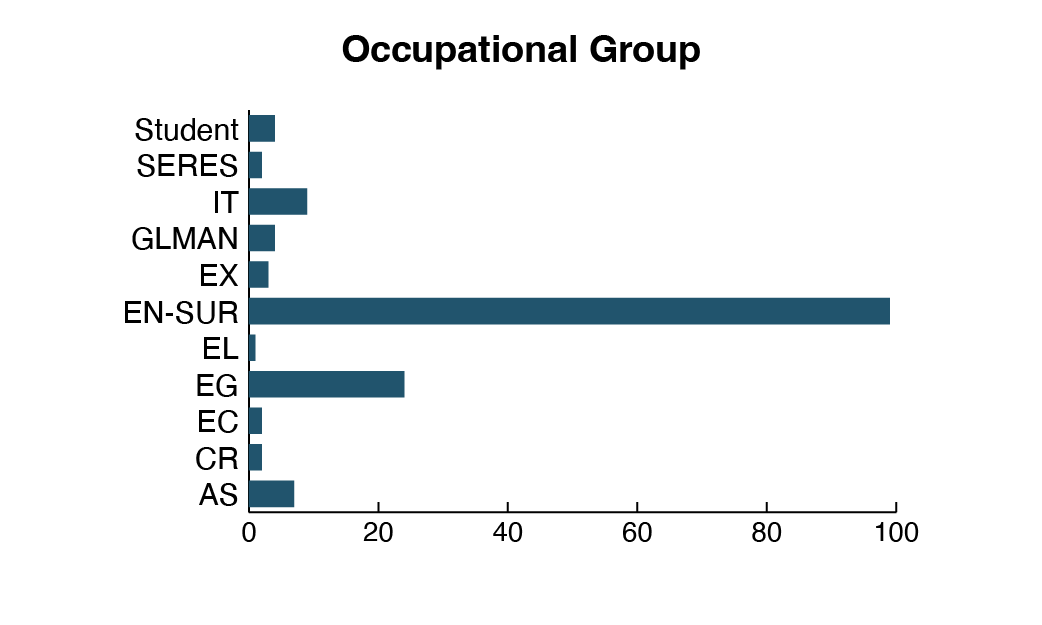
Description of figure 1
Bar chart showing the number of Surveyor General Branch employees by occupational group for fiscal year 2023–2024. The largest group is Engineering and Land Survey (EN SUR) with 99 employees. Engineering and Scientific Support (EG) has 24 employees. Information Technology (IT) has 9 employees. Administrative Services (AS) has 7 employees. General Labour and Trades (GLMAN) has 4 employees. Students account for 4 employees. The Executive (EX) group has 3 employees. Clerical and Regulatory (CR), Economics and Social Science Services (EC), and Scientific Research (SERES) each have 2 employees. Electronics (EL) has 1 employee.| Group | Definition | Count |
|---|---|---|
| AS | Administrative Services | 7 |
| CR | Clerical and Regulatory | 2 |
| EC | Economics and social science services | 2 |
| EG | Engineering and Scientific Support | 24 |
| EL | Electronics | 1 |
| EN-SUR | Engineering and Land Survey | 99 |
| EX | Executive | 3 |
| GLMAN | General Labour and Trades | 4 |
| IT | Information Technology | 9 |
| SERES | Scientific Research | 2 |
| Student | Student | 4 |
| Total | 157 |
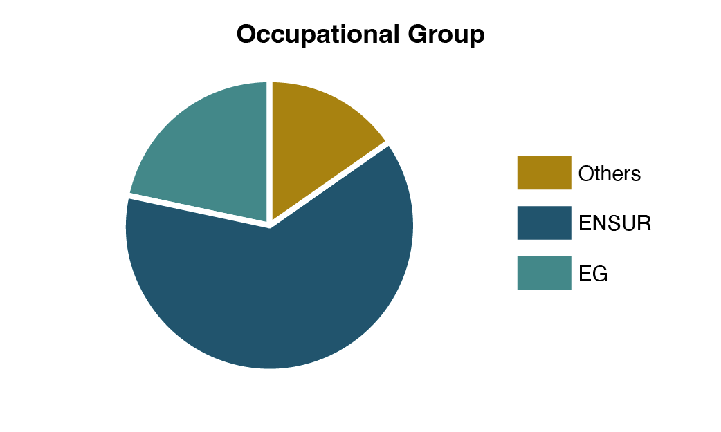
Description of figure 2
Pie chart showing the percentage distribution of Surveyor General Branch employees by occupational group for fiscal year 2023–2024. Engineering and Land Survey (EN SUR) represents approximately 63% of employees. Engineering and Scientific Support (EG) accounts for about 15%. All other occupational groups combined represent approximately 22%.