
In the second of our series of CFS photo galleries, step into the landscape with stunning photos captured by Canadian Forest Service researchers at work.
From the quiet beauty of lichens stretching across the northern boreal forest to the thrill of a double rainbow after a long day in the heat, Canadian Forest Service researchers see Canada’s landscapes in ways most people never do. The photo gallery here opens a window into that world — where science, adventure and discovery meet.
Our researchers spend weeks and months in the field, often hiking rugged trails, swatting clouds of insects or flying into remote sites by helicopter. Along the way, they carry cameras as well as their notebooks and instruments.
Now you can see some of the landscapes and the unexpected surprises that make the field both a workplace and, for many, the most beautiful office in the world.
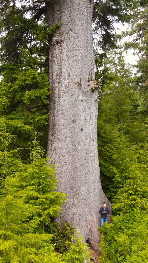
Standing tall and strong
On a site visit to the forests near Port Hardy for a project with the Indigenous Forestry Initiative program, we were guided to this awe-inspiring spruce — an ancient survivor standing strong through decades of windstorm, insect outbreaks and logging. It is a living testament to resilience and history. — Chengdong Fang, forestry development officer
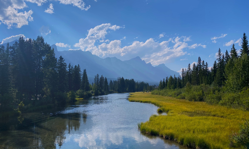
Where river meets sky
A view of Policeman Creek from its boardwalk trail, named after the North-West Mounted Police post once located along the shore, as it snakes through downtown Canmore, Alberta. Mt. Rundle can be seen in the distance. I captured this photo during a brief and incredibly scenic stop on our crew’s journey from the Pacific Forestry Centre on Vancouver Island to northern Saskatchewan, where we were heading out in the field to collect forest soil samples in a series of jack pine–dominated stands. — Jessica Walker, scientific support technician
Science in our backyard
At the Atlantic Forestry Centre in Corner Brook, Newfoundland, we’re lucky to have Gros Morne National Park right in our backyard. It’s a place that offers both inspiration and adventure. Our researchers head there often for fieldwork, sometimes even by helicopter to reach remote sites! We partner with the park on all kinds of research, from biodiversity and species at risk to forest pests, climate change, sustainable forest management and soil science. This photo was taken near the Shallow Bay campground on one of my many visits to the park — a spot that never fails to remind me of how fortunate we are to work in such a place. — Doreen Churchill, director of the Corner Brook Research Facility
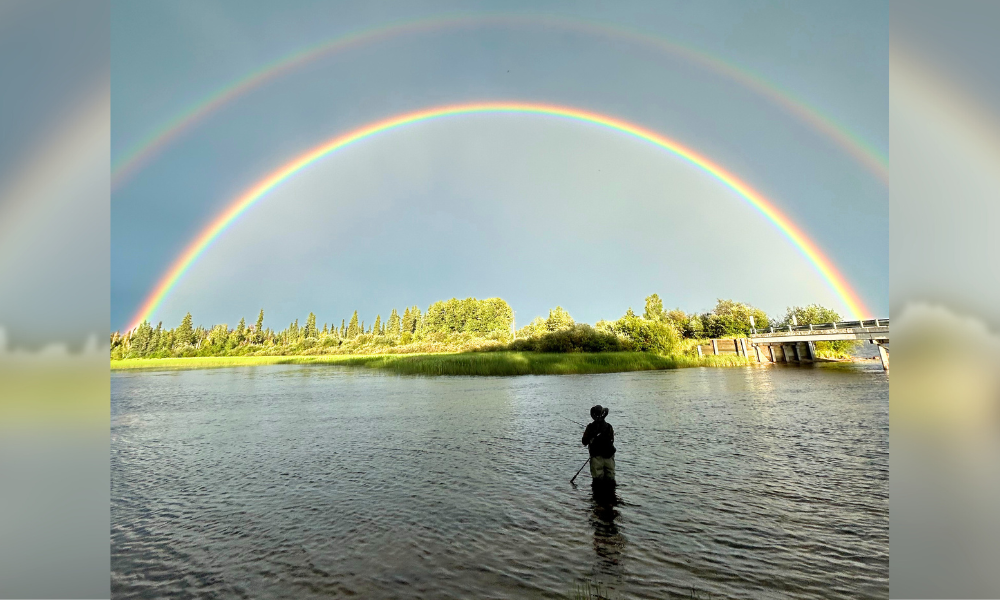
Double rainbow over Christina Lake
Our team was sent up to Conklin, Alberta, in the summer of 2024 to collect pitfall traps to study arthropod biodiversity along seismic line complexes throughout the boreal forest. The July heat presented quite a few challenges, including working on unshaded peatlands in +35°C conditions. But the vision of beautiful Christina Lake kept us going, slogging through the tough terrain. One evening our efforts were greatly rewarded as we were greeted by the most intense double rainbow ever, lurking in the evening dusk. The skies brightened up, despite the cloudy overcast. It turned into one of the most magical experiences. — Norbert Nguyen, laboratory technician and Philip Hoffman, insect biodiversity technician
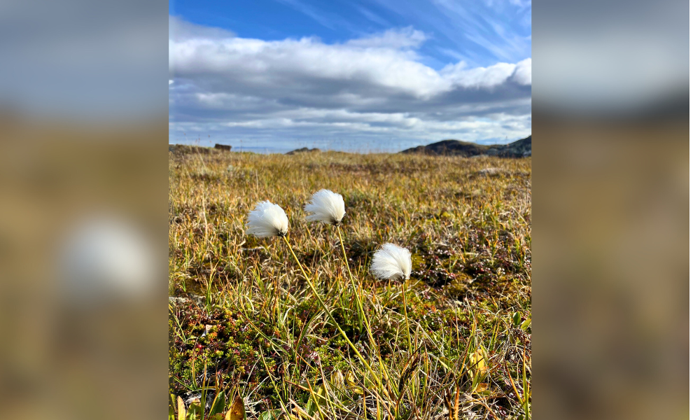
Cotton clouds and clouds of cotton
Come fall in Nunavut, the landscape transforms with the abundance of cottongrass, known to the Inuit as Arctic cotton (kanguuyat). Its distinctive small, silky-white flower heads are scattered across the damp parts of the city and throughout the tundra, as seen here in Qaummaarviit Territorial Park, near Iqaluit. This flower was easily my favourite out in nature. I especially loved watching people gather them to create beautiful bouquets that brightened up our homes. While undoubtedly gorgeous, Arctic cotton is also incredibly versatile and remains an important resource for the Inuit communities. — Marie-Krystel Gauthier, molecular biologist
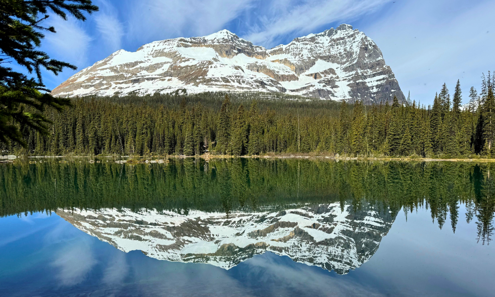
Reflections at Lake O’Hara
I took this picture on a very snowy July morning in Yoho National Park, B.C. We were hiking along the Lakeshore Trail around Lake O’Hara along with my 94-year-old mum and my 17-year-old son. Mount Schaefer was reflected perfectly on the lake’s glassy surface. It was magical, so calm, with only the distant hum of the Seven Veils Waterfalls, the occasional caw of a raven or cry of an eagle, and the sudden far-away thundering crash of snow cascading down from the peaks in the morning sun. It was a moment to remember. — Geordie Hobart, physical scientist
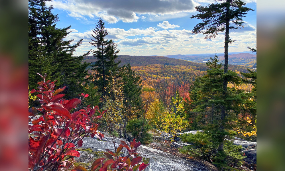
Mont Otis
On an autumn hike with friends, I discovered Mont Otis in Mauricie, Quebec. The view from the summit stopped me in my tracks: the colours of the tree species revealed the diversity of the region’s mixed forests. These mosaics of red, gold and green reflect forest dynamics that unfold over centuries. In contrast, the rocky outcrops remind me of the ancient Canadian Shield, which has stood for more than a billion years. This landscape, both fleeting and timeless, invited me to put my daily concerns into perspective and to better appreciate the depth of time expressed here. — Nelson Thiffault, research scientist

A lake with no name on a road with no name…
On a partly cloudy but otherwise beautiful day, trees perfectly reflected off the calm water of one of Ontario’s many unnamed lakes, found down a little-used forest road somewhere near Woman River. I was in the area putting up bioacoustic recorders — devices that capture bird calls — to find out which migratory birds make this corner of Canada’s boreal forest their temporary home. — Danielle Greco, forest biologist
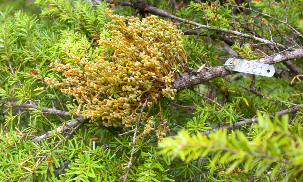
Up close with dwarf mistletoe
This shows the shoot growth of western hemlock dwarf mistletoe (Arceuthobium tsugense (Rosend.) subsp. tsugense) on western hemlock (Tsuga heterophylla) branches. This image was taken at Cowichan Lake on Vancouver Island, while conducting research on biological control of hemlock dwarf mistletoe, a widespread and damaging parasite in British Columbia’s coastal hemlock stands. — Simon Shamoun, research scientist
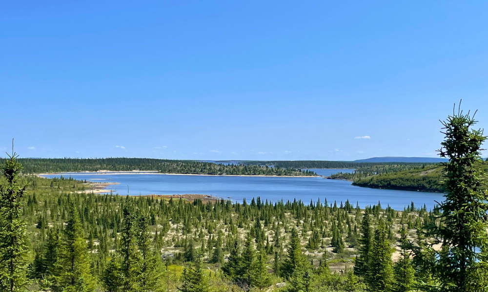
As far as the eye can see
As part of my work, we study forest fuel, which is the vegetation found in the forest that can fee wildfires, in northern Canada. Here, on the edge of the Laforge-Deux Reservoir, I was able to capture the spirit of the Quebec taiga: lichens and lakes stretching endlessly, with scattered black spruce. The immensity of the land is breathtaking, but it also comes with a warning: complete isolation. It takes three days of driving to reach this place, and the nearest village is about 400 kilometres away. I count myself lucky to have a job that lets me set foot on this legendary landscape. The days are long and sometimes cold and rainy, and thousands of thirsty flies always seem to show up. But even with these challenges, I truly have the most beautiful office in the world. — Maxime Nolan, forest technologist
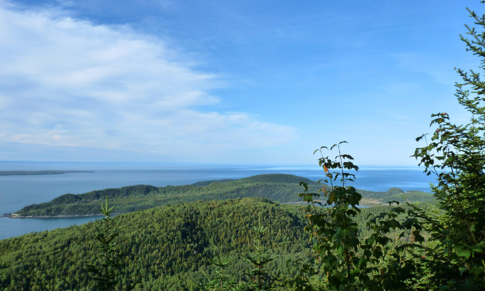
A breathtaking view
I took this photo at Bic National Park near Rimouski, Quebec. It’s a beautiful area along the St. Lawrence River known for its scenic landscapes and rich biodiversity. Visitors can enjoy being in a beautiful tree and herbaceous vegetation environment and observing a variety of bird species. From an observation point high above sea level, I was impressed by the remarkable transformation from the forest to the immensity of the river. A few years later, I was invited by Professor Sven Erik Jorgensen, then Editor of Ecological Modelling to contribute as editor on a volume on ecological forest management, to be published by the Taylor & Francis Group/ CRC Press. I suggested this image for the first edition book cover, where it appeared alongside photos of coniferous, deciduous and tropical forests. More recently, an image of a deciduous forest on the cover made me realize more than ever how small and interconnected our world can be. Today, I often use the photo during Zoom sessions. In a recent meeting with colleagues in the U.K. and U.S., they were surprised to learn that the hardwood forest is located near a site used by the British army during the Battle of Quebec in 1759. This decisive battle of the Seven Years’ War helped shape the fate of North America. They were amazed by this connection. — Guy Larocque, research scientist and editor of the Ecological Forest Management Handbook
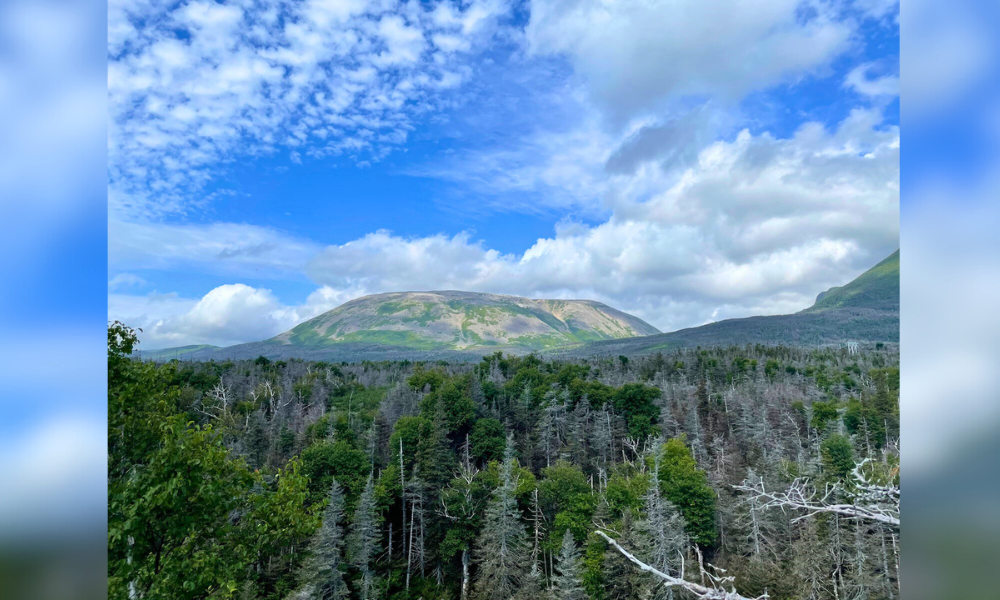
Spruce budworm at Gros Morne
I took this photo about two kilometres along the Gros Morne trail, in Gros Morne National Park, N.L. In the foreground you can see the birches (Betula papyrifera) are all foliated — their branches covered in green leaves — while most of the balsam fir (Abies balsamea) trees are dead or dying following several years of defoliation by the eastern spruce budworm (Choristoneura fumiferana). Balsam fir mortality typically occurs after about three to five years of heavy defoliation. Gros Morne is the second-highest point in the island of Newfoundland, rising to 806 metres. — Joseph Bowden, research scientist
