
“This isn’t just about making maps — it’s about creating a system where information is always current, always accessible and always actionable.” — Aliyan Haq, Geomatics Analyst, Natural Resources Canada
Geospatial information, or data connected to a specific place on Earth, is one of the most powerful tools we have to understand and respond to the world around us. For anyone who is managing wildfires, designing smarter cities or tracking the effects of climate change, access to accurate, up-to-date and reliable geospatial data is essential.
The seven-second summary:
Canada’s Geospatial Web Services is revolutionizing access to up-to-date geospatial data through an automated tool called the Web Services Harvester. Developed by Natural Resources Canada as part of the Canadian Geospatial Data Infrastructure, the Web Harvester automatically finds and organizes online maps and location-based data from over two thousand live geospatial web services across the country. It brings those services together into one searchable location so people can find the information they need more quickly.
From tracking climate change to responding to emergencies, researchers, planners and policymakers can access the continually updated catalogue so they can make informed decisions faster. They can filter results by service type, provider and theme, helping them find exactly what they need in minutes.
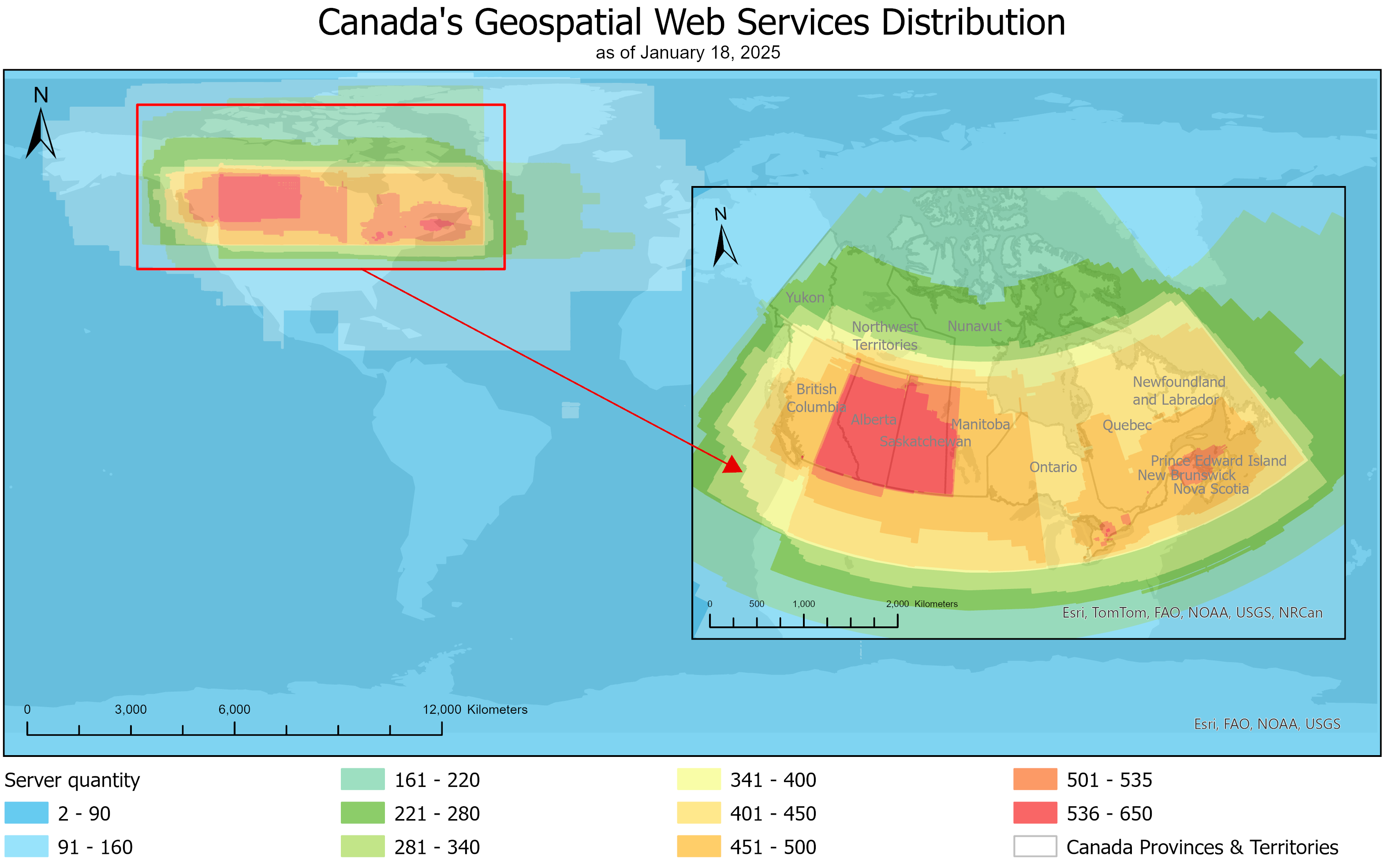
The locations of geospatial web services across Canada, with areas of the highest concentration highlighted in red. The map provides a clear overview of how these digital mapping services are distributed nationwide.
The core collection
At its core, the Web Harvester is a collection of data gathered from live geospatial web services. As of September 1, 2026, it:
- covers all of Canada and the Arctic
- features over 64,000 unique map layers sourced from over 2,300 servers
- includes 35,492 Government of Canada map layers sourced from over 713 servers, including those from Meteorological Services of Canada, Environment and Climate Change Canada, and Agriculture and Agri-Food Canada
Each map layer contains a specific type of geographic information — such as roads, forests, wildfire locations, weather conditions and population data — that can be viewed individually or combined with other layers to create a more complete picture.
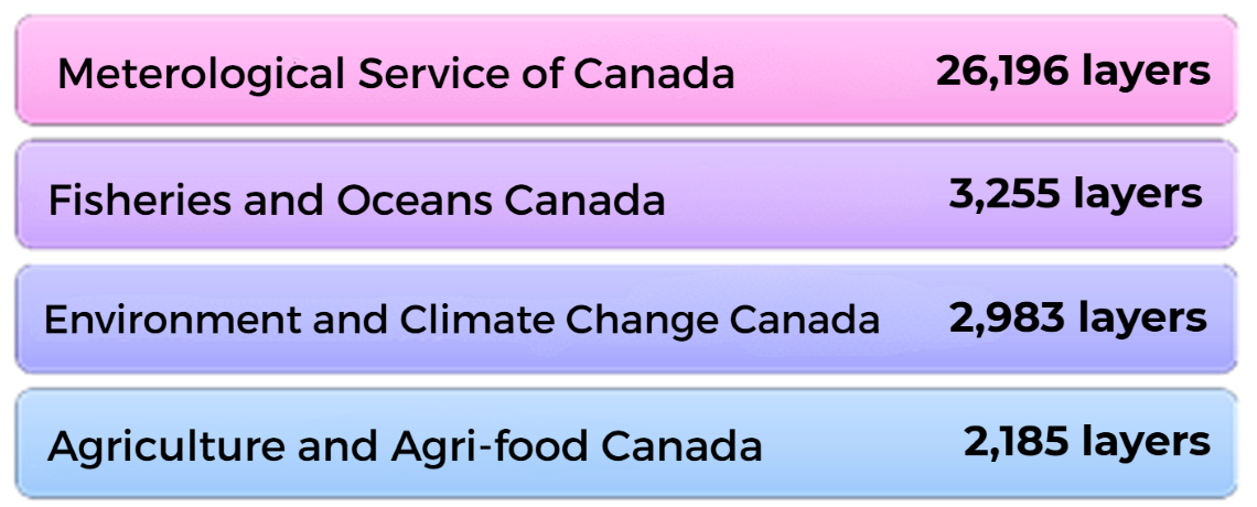
The Meteorological Service of Canada provides by far the largest number of geospatial data layers, followed by Fisheries and Oceans Canada and Environment and Climate Change Canada.
A wide variety of users
Users from across all sectors with a wide variety of specific needs can benefit by using the Web Harvester:
- Emergency responders can access live data during wildfires, floods, and storms
- Public health officials can track the spread of disease with geographic precision
- Farmers can assess crop health and access soil data
- Urban planners can visualize growth patterns and infrastructure needs
Spotlight on the Arctic
Geospatial data is especially critical in the North, where changing conditions require up-to-the-minute information. Almost 50 percent of Arctic metadata entries have been filtered and improved automatically, saving researchers valuable time in finding suitable data. Through the Arctic Spatial Data Infrastructure, the Harvester supports:
- climate research on permafrost and sea ice melt
- Indigenous land use, planning and management
- Arctic shipping route planning as sea ice conditions evolve
Smarter data through automation and artificial intelligence
While the impact of the Geospatial Web Harvester is already notable, the system is evolving rapidly, from 5,000 layers in 2019 to more than 60,000 in 2024.
Machine learning is being used to fill in metadata gaps, and automated testing helps ensure its reliable.
Integration with global datasets from agencies like the National Oceanic and Atmospheric Administration in the United States and the European Space Agency is underway. These advances will help the Harvester grow smarter and faster so it can bring in more data from more sources.
In closing
“This tool has fundamentally changed how we manage and access geospatial data across the country and in the Arctic. With automation, AI and a commitment to open data, this system not only is a technical achievement but also provides a valuable public asset.” — Aliyan Haq, Geomatics Analyst
Discover more:
Geospatial web services harvester
Geospatial Web Services Catalogue
Canadian Geospatial Data Infrastructure Resource Centre
Arctic SDI Metadata Catalogue