
Uncovering the ecological origins of ancient toolstones around Harrison Lake, British Columbia
June 2026
When geologists and archaeologists teamed up with Sts’ailes knowledge holders on the shores of Harrison Lake in southern British Columbia, they weren’t just searching for rocks. They were tracing relationships, specifically the connections between ancient volcanoes and modern villages; between how rocks in the territory formed and where people collected them to make stone tools: and between western science and teachings that come from the land itself.
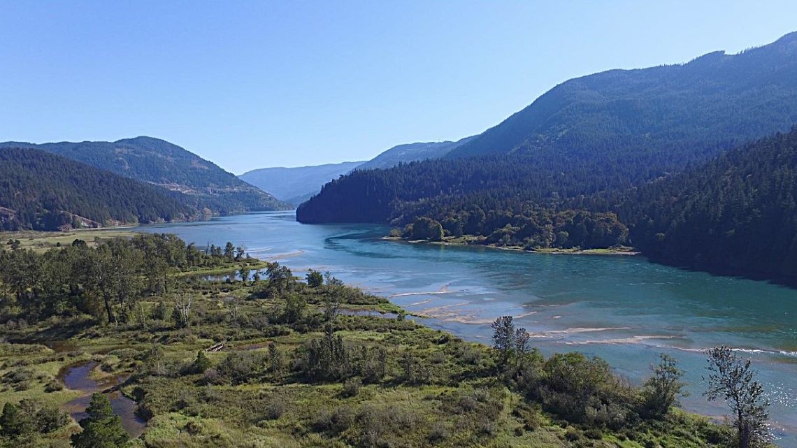
The Harrison Lake watershed, north of Harrison Hot Springs and south of Lillooet, lies within Sts’ailes territory in southern British Columbia. Here, rivers, forested mountains and volcanic rock formations have guided Sts’ailes travel, trade and toolmaking for more than 10,000 years. (Photo: Morgan Ritchie, Sts’ailes)
New ways to do science
“This area is geologically significant, as it holds the secret to how different parts of the southern Coast Mountains were formed in the distant past,” explains Martyn Golding, a research scientist with the Geological Survey of Canada (GSC) at Natural Resources Canada (NRCan). “This work is about exploring new ways to do science and about actively advancing reconciliation by partnering directly with First Nation communities.”
Geologists often think about the Earth across immense time scales. Kelsey Charlie (Tixweltel), a Sts’ailes historian, cultural knowledge keeper and a director with the Sts’ailes First Nation, also takes a long view — one rooted in teachings about Xexá:ls, a transformer figure in oral history who is said to have shaped the land and established laws for living responsibly on Solh Temexw, the Sts’ailes traditional territory.
“Sts’ailes Xwelmexw Mestiyexw have since time immemorial lived in harmony with all living things within the Sts’ailes Solh Temexw community,” says Kelsey. “All of the agreements and arrangements that were made at the time of Xexá:ls express how we are supposed to live and take care of everything on Solh Temexw. Today, we still live by these laws and teachings, upholding our original agreement.”
“Almost all Sts’ailes teachings and knowledge come from the land,” says archaeologist Morgan Ritchie, who has worked with the Sts’ailes for nearly two decades. “Stone outcrops hold history and wisdom. Seeing geologists and community members read those outcrops together has been profound.”
A community’s question sparks a pilot project
The Sts’ailes project was triggered by a deceptively simple question: Where did the stone for our ancestors’ tools come from?
“Our previous work in Sts’ailes territory identified a rich and varied toolstone landscape, which we linked directly to tools found in Sts’ailes archaeological sites using geochemistry,” explains Rhy McMillan. He began this work while at the Social Sciences and Humanities Research Council of Canada and continues it now as a physical scientist and geoscience advisor to the GSC’s Indigenous Relations Network.
“Understanding the bigger picture — when, how and where the rocks formed — required the specialized skills of GSC researchers and therefore provided an excellent jumping-off point for this collaborative research.”
Unravelling that mystery set the direction for a collaborative pilot project with NRCan, bringing archaeologists, geologists, youth and Elders into the field together.
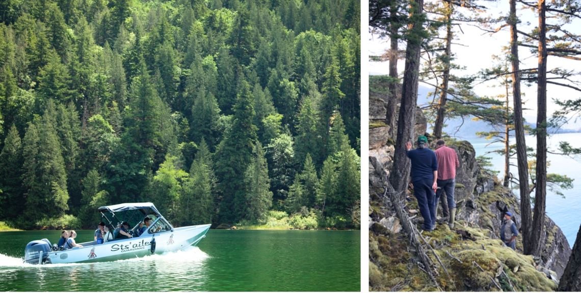
Researchers and Sts’ailes community members travel on the Sts’ailes Guardians’ boat to field sites along Harrison Lake. (Photo: Morgan Ritchie, Sts’ailes
Two lenses, one landscape
This is an ancient landscape, where tall, ice-capped mountains reach down to the water. There’s a sense of history in the stillness in the bays and coves of the lake. As the team works, motoring along in a boat in search of geological outcrops, the geological scientists and Sts’ailes community members deliberately intertwine traditional and scientific knowledge to collaboratively enrich both perspectives:
- Traditional knowledge and teachings situate rock outcrops within Sts’ailes identity, mapping cultural memory through named places and pictographs.
- Geological mapping and sampling trace volcanic and sedimentary sequences, microfossils and geochemical signatures to help identify and characterize likely toolstone sources.
This approach engages two timelines at once: millions of years of geological change and more than 10,000 years of Sts’ailes presence in the Harrison River watershed, stretching back to the retreat of the glaciers. Together, these timelines show how landforms, routes and resources have shaped life, travel and trade
For the past four years, GSC–Sts’ailes teams have examined Mesozoic sedimentary and volcanic rocks around Harrison Lake, mapping outcrops and integrating observations with Sts’ailes place-based knowledge and archaeology, including pictographs that mark culturally important sites.
Uncovering Earth’s history
It’s very physical work: hiking through overgrown bush and snow; climbing in and out of boats; carefully extracting rare fossils; diligently marking the locations of samples on maps; and driving on long-abandoned logging roads on the side of mountains. And every step of the long journey requires adaptability and attention to detail, as the teams work to uncover pieces of Earth’s history.
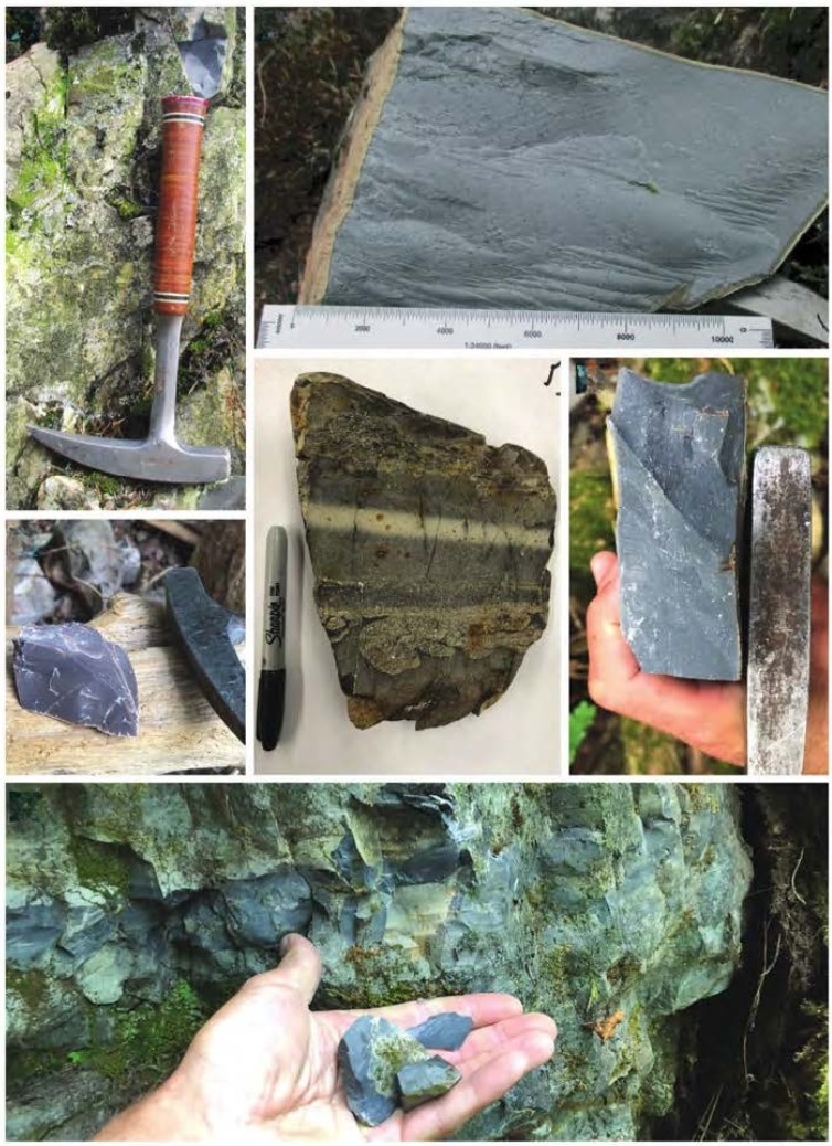
Rock specimens from Sts’ailes territory are carefully measured, photographed and analyzed during field work as researchers work to trace ancient stone tools back to the outcrops where they were first shaped. (Photo: top images, Kaitie Purdue; remaining images, Rhys McMillan)
What the rocks reveal
The Harrison Lake region is built from ancient marine sediments and the remains of long‑past volcanic eruptions, forming an island‑arc landscape born in the age of dinosaurs. Imagine a chain of volcanic islands, like a distant cousin of modern Japan, forming and collapsing over tens of millions of years. Ash layers hardened into tough, fine-grained rock. Lava flows cooled. Mud and sand sank to the sea floor. Some of those materials became ideal sources for sharp, durable tools.
The geological landscape of the Harrison Lake region includes numerous marine fossils that are found in the rocks formed within a volcanic island environment.
“There are many diverse and unusual forms, all of them different species of animals, each of which evolved over time and eventually became extinct, as all life forms do,” explains GSC research scientist Jim Haggart. “Because of their uniqueness in Earth history, these fossil species stand as markers for the specific intervals of geologic time that they lived in, and these time intervals can be recognized all over the globe, wherever the same fossils are found.”
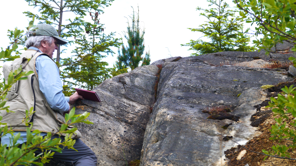
Research scientist Jim Haggart taking measurements to define the orientation of a rock face.
New fossil finds help the team pin down the ages of key rock units, which are part of a bigger puzzle linking specific toolstones to how and when the rocks formed.
Geochemical studies, which provide “chemical fingerprints” of rocks, show how different rock units are genetically related and reveal signs of past volcanic activity and sedimentary environments. These findings help establish stronger links between rock units on either side of the lake. These chemical clues also help researchers better assess where other undocumented toolstone outcrops may be exposed, knowledge that is particularly significant for Sts’ailes.
Following the toolstone across the water and history
Sts’ailes travel routes trace the water, and so does the stone. Villages were located along rivers and lake shores, and most quarries were accessible by boat.
At one ancestral village site, Sts’ailes researchers found about 20,000 pieces of rock debris and 160 finished tools, firm evidence of intensive toolmaking.
“To understand the toolmaking workshops like this one, we worked to locate the quarries where people obtained raw materials, which deepened our interest in understanding the geology of the territory,” says Morgan. “And to understand the geology, we turned to the land and to the people who know it best.”
Most bedrock quarries, it turns out, are mentioned in ancient narratives and marked with pictographs, ancient images painted on rocks, caves and cliffs with natural pigments.
Guided by the land
Identifying the geologic source of stone tools requires a holistic approach integrating Indigenous knowledge, archaeology and geology within a robust scientific framework. The detailed and accurate documention of Sts’ailes toolstone acquisition strategies has several uses: it supports land‑use planning and heritage preservation; informs Sts'ailes guardian activities on the water; and rebuilds knowledge of traditional skills lost after European contact.
Understanding the geologic context of toolstone is a key component to achieving these results. More generally, it also offers a model for research that is community‑directed, culturally grounded and scientifically rigorous.
“It’s amazing to see the level of deep knowledge, including the way the earth was formed from a longer‑term perspective,” says Morgan. “Putting microfossils, chemistry and teachings side by side changes how we see the territory and how we care for it.”
The road — and the river — ahead
Next steps for Sts’ailes include working with the GSC to continue contextualizing toolstones in the territory, collaborating on other geological projects within their territory and co‑developing curriculum and map‑based tools for Sts’ailes youth.
And as more layers of knowledge are uncovered, the Harrison Lake story becomes even richer: an island‑arc past, a living cultural landscape and a shared journey to read the rocks, ensuring that these ancient witnesses can continue guiding people as they have always done.
If you’re a member of the media or an educator and would like to learn more about this work, contact Simply Science at: sciencecommunications-communicationsscientifiques@nrcan-rncan.gc.ca.
This project was partially funded through the GSC’s Indigenous Relations Network as a pilot to develop new ways of doing research with Indigenous communities.
Discover more:
Engaging with remote communities to map the local bedrock (Simply Science video)