
Important update to the maps will help guide planting decisions across the country
July 2025
By Jackson Lyons for Simply Science
Did you know there’s a specialized map to help you determine which plants will thrive in your backyard? It’s called a plant hardiness zone map, and — for the first time in over a decade — Canada’s version is getting an update.
Thanks to efforts by scientists at Natural Resources Canada (NRCan), Canadian gardeners, farmers, growers and foresters from coast to coast to coast now have a new, more accurate source of information for making planting decisions.
The plant hardiness zone map has existed in Canada since the 1960s, but a lot has changed since then. From shifting climate conditions to new plant varieties, updates like this — combining the best of climate science and plant modelling expertise — are essential to keep the map up to date and reflect new growing conditions and challenges.
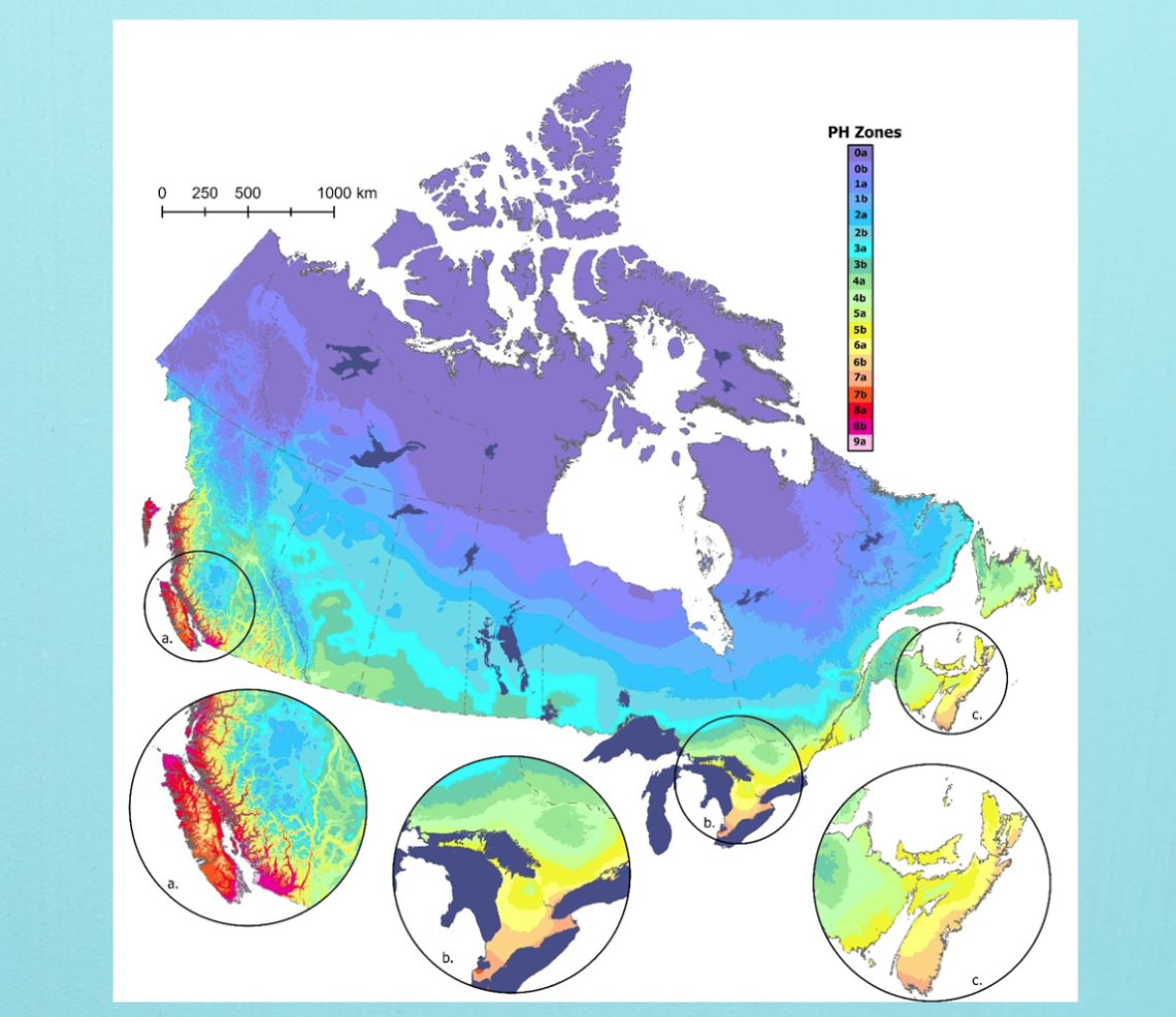
Canada’s Plant Hardiness Zone Map has received its first update in more than a decade.
Hardiness zones on the move: What’s changed?
No one better understands the details and complexity of this project than Canadian Forest Service researchers Dan McKenney and John Pedlar, the plant hardiness experts who have coordinated several updates to the hardiness zone map over the past couple of decades.
“People say pictures tell a thousand words, and I believe that’s also true with maps,” Dan says.
Compared with earlier versions, the new map shows a small but significant warming shift in many parts of the country, with many areas shifting by half a zone or more and some by as much as two full zones.
For example, Yellowknife, Northwest Territories, formerly in zone 0b is now in zone 1b, a full zone increase. This suggests the potential for new plant species to grow in this area, including shrubby species such as Saskatoon berry (Amelanchier alnifolia) and red osier dogwood (Cornus sericea).
These changes can have wide industrial and economic effects. For example, the practice of viticulture — the cultivation and harvesting of grapes — is expanding in Ontario to areas north of the province’s traditional wine-growing region in the southern part of the province. However, these changes can also pose a risk for plants being introduced to new hardiness zones. Extreme climate events, like late frosts, droughts and drastic temperature swings, are still possible under a warming climate.
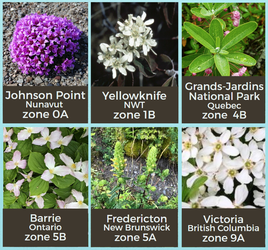
Canada has many different plant hardiness zones, from 0 in Nunavut to 9 on Vancouver Island.
How plant hardiness zones work
The plant hardiness zones are rated 0 through 9, based on climate conditions such as temperature, precipitation and frost duration at locations across Canada. For example,
Zone 0 covers the coldest parts of northern Canada, where only the hardiest of plants can grow, while Zone 9 covers much warmer parts of Vancouver Island, where a wider variety of plants can grow, including certain palms and citrus varieties.
These hardiness zones are uniquely tailored to our landscapes and climate. They’re based on several important climate variables, including:
- lowest average daily temperature in the region’s coldest month
- length of frost-free periods (above 0°C)
- rainfall totals from June to November
- highest average daily temperature during the zone’s hottest month
- severity of winter
- average maximum snow depth and wind gust over the past 30 years
Gardening and growing for green thumbs
The hardiness zones are classified by simple numbers, but behind each one is a wealth of data — and local wisdom. “These maps are definitely super popular,” says Dan. “For many Canadians, gardening is their favourite pastime.”
In fact, gardening is so popular in Canada that the greenhouse, sod and nursery industries brought in more than $4 billion in sales in 2021, according to Statistics Canada. That’s one of the reasons why it’s crucial that these zone maps are well researched and informed by people familiar with their local flora. “It’s fulfilling to be part of a project that facilitates such a wide breadth of applications for so many,” says John.
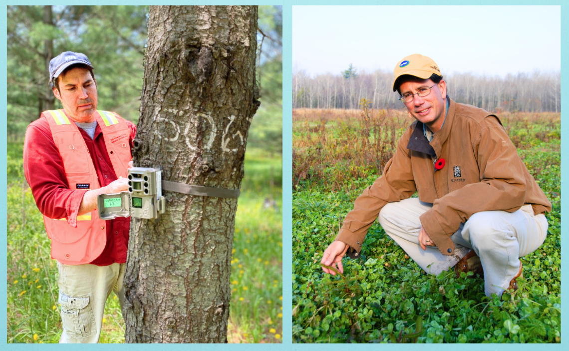
The principal researchers, left, John Pedlar, and right, Dan McKenney, have been working together for years to compile this first update to Canada’s Plant Hardiness Zone map and website in more than a decade.
Individual species maps on the website
The website version of the new zones also provides maps for thousands of individual plant species. These detailed maps represent some of the latest science in species distribution modelling (SDM), a method used to predict where a species may be able to live based on both current and future climate conditions. For this work, Dan and John make use of a large database of plant occurrence locations generated from professional and citizen science submissions across North America.
Maps created with SDM can show where on the continent the climate is suitable for a particular species and by incorporating the latest climate change scenarios, where growing conditions may develop in the future. These maps complement the general hardiness zone map by providing planting guidance for specific species of interest. One day, if reliable SDMs are generated for enough plant species, this approach may even become the preferred approach for making planting decisions!
The seasons ahead
What’s next for the future of these hardiness zone maps? With more frequent heatwaves affecting plants, Dan and John are now turning their attention to creating a heat zone map to identify areas that may experience excessive heat events. They also believe there is scope to generate more customized maps for individual species. They’re currently assessing the possibility of a project to help Agriculture and Agri-Food Canada build similar models for apple varieties.
“I’m always interested in seeing how climate is changing and what the implications are for plant distributions, both in nature and in people’s gardens,” says John.
So, whether you’re an amateur gardener, an experienced family farmer or a professional ecologist, the plant hardiness zone website provides a storehouse of valuable information for choosing plants that will thrive in a particular area.
See for yourself: explore the new maps and discover what’s possible in your region — you might be able to grow something new!
If you’re an educator or a member of the media looking for more information on this interesting project, contact us at sciencecommunications-communicationsscientifiques@nrcan-rncan.gc.ca
You can read more about this research in the Scientific Reports section of Nature online.